Gilkey Trench Fieldwork Adventure

By The Gilkey Trench Crew (Jamie Bradshaw, William Jenkins, Jon Doty, and Justyna Dudek)

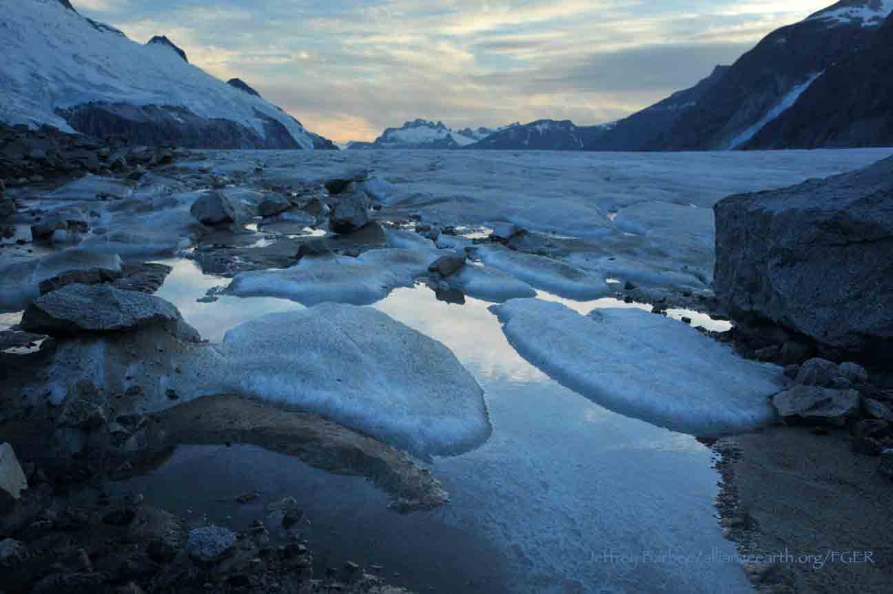
While many students already started the fieldwork for their projects at Camp 10 and even Camp 18, five students have been anxiously awaiting to begin their fieldwork in the Gilkey Trench. The Gilkey Trench is the magnificent view that you see from Camp 18 where the Gilkey, Vaughan-Lewis, the Unnamed and many other glaciers connect and flow down through the steep, glacially carved, 2,000 foot deep valley. The Trench is filled with beautiful curving medial moraines and jaw dropping ogives created by ice falls. Getting to such a beautiful place is not easy and well worth a full day’s effort.

Descending "The Cleaver" - approaching the start of the series of fixed ropes - with the Gilkey Trench in the background.  Photo by Adam Toolanen

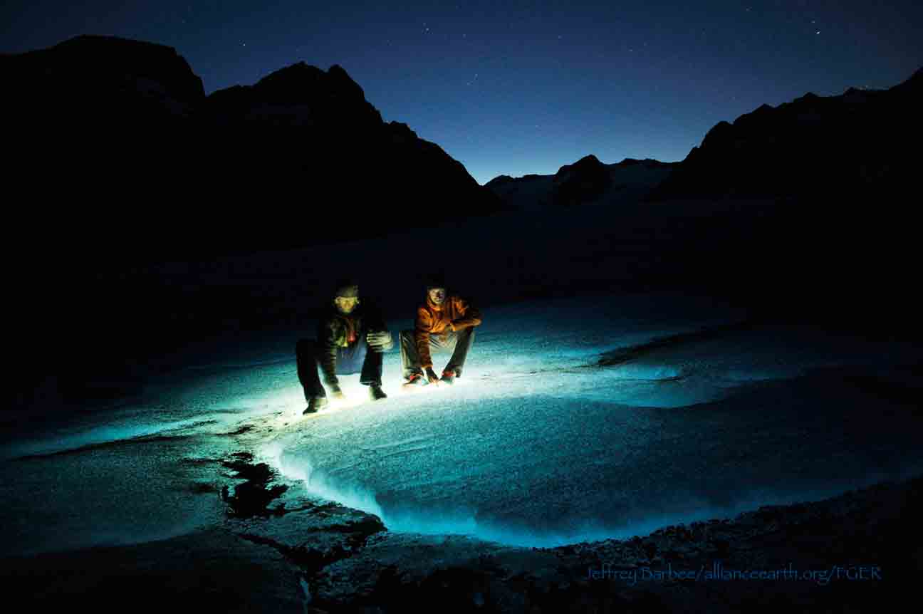
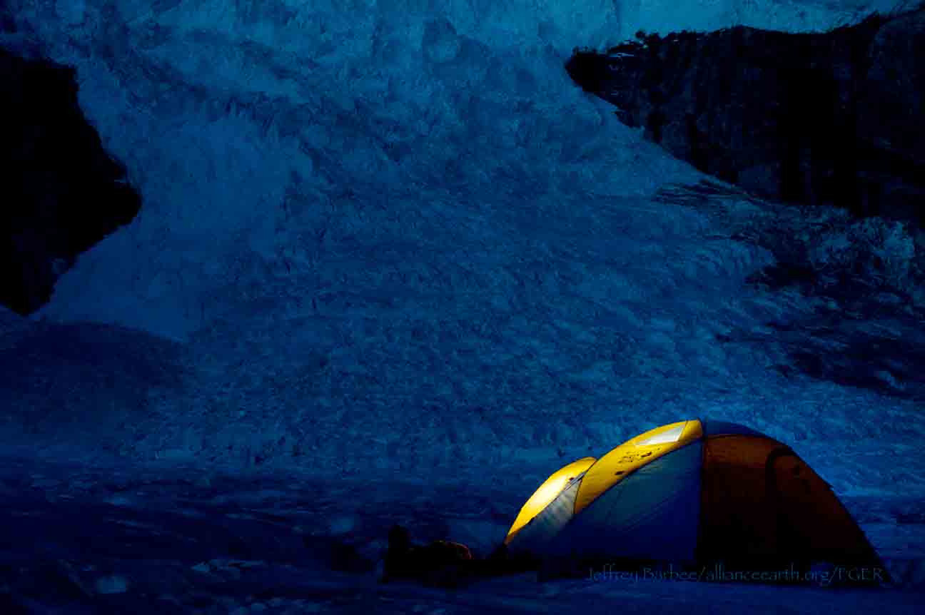
On Wednesday, July 31st, these students and four safety staff members departed Camp 18 for our camp on the bare glacier ice in the sunshine. The trick to getting to the glacier is descending what is affectionately called “The Cleaver.” The Cleaver is the 2,000 feet of bedrock that sits between Camp 18 and the glaciers below.  The descent was led by senior staffer Scott McGee, who has done the route many, many times. The first half of the route was going down steep snow slopes until we got to a vegetated area called “The Heather Camp.” This is where the fixed ropes began.

Waiting in a safe location - protected from rockfall from above - for their turn to descend the next section of fixed ropes.  Photo by Adam Toolanen. 

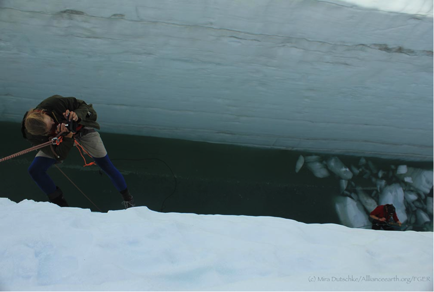
Here, the students and staff put on helmets and harnesses and tied into the fixed ropes with a knot called a prussik. This rope system served as a back up in case there was a slip on the steep, unstable terrain.  Fixed ropes were used for the last half of the descent because the route became steeper and more exposed. Because the glacier is melting, new bedrock and rock debris is left behind. This makes finding new routes difficult and challenging in the unstable footing. After 11 very long hours, the students and staff safely and happily arrived at our camp in the Gilkey Trench during a magnificent sunset.

Scott McGee scouts the lowest section of the descent made of freshly exposed bedrock, and precariously deposited boulders left by the rapidly thinning Gilkey Glacier.  Photo by Jeffrey Barbee. 

The next two days were spent collecting data from the field. A brief explanation of the students’ projects in the Gilkey Trench are below:

Jamie Bradshaw - Surface Ablation of the Gilkey Glacier

For my project, I looked at the ablation, or melt rates, of the Gilkey Glacier. In May 2013, wires were steam drilled into the ice for Dr. Anthony Arendt at the University of Alaska Fairbanks (also a visiting JIRP Faculty member earlier in the summer). My task was to find these wires and measure how much wire was exposed. Luckily the sites came with known GPS coordinates and had a wire tetrahedron with bright orange flagging attached to it, so it was fairly easy to find in the rolling, mildly crevassed terrain of the Gilkey Glacier. By knowing the length of the wire exposed at the time of installation (which I will find out upon returning to civilization) and measuring the length of wire exposed in August, the ablation can be determined. This becomes important because once the area of the glacier is known, the total amount of melt water runoff from the glacier to the ocean can be calculated.

Jamie Bradshaw photo documents one of the ablation-measurement sites on Gilkely Glacier.  As the glacier surface melts, more wire (at Jamie's feet) is exposed.  Photo by Jeffrey Kavanaugh. 

William Jenkins - Ogive Survey

My research in the Gilkey Trench was focused on the ogives, also called Forbes Bands, which form at the base of the Vaughan Lewis Icefall, adjacent to Camp 18. These interesting features in the ice are annual formations that only appear beneath fast flowing icefalls. It is commonly accepted that their light and dark banding represents the variations between summer and winter ice that has made its way through the icefall in one year. Summer ice, which is subjected to wind blown particulates and increased melt, constitutes the dark bands of the ogives and forms the trough of their frozen wave-like appearance. The white winter ice is composed of that year’s snowfall, and forms the crests of the wave bulges. 

William Jenkins surveys one of the Gilkey Glacier ogives with GPS.  "The Cleaver" is the ridge of rock in the background, with the Vaughan Lewis Icefall on the right.  Photo by Jamie Bradshaw. 

The purpose of my study was to determine how fast this area of the Gilkey Glacier was thinning in comparison to previous years. In order to determine this rate, I conducted a longitudinal GPS survey, with the help of Scott McGee, that had previously been carried out from the years 2001-2007. As a result of the glacier’s rapid thinning rate, I’ll be able to calculate its subsidence by the changes in the elevation of the survey over time. I will also compare the data I observe with the Vaughan Lewis mass-balance data that JIRP has collected over the years. This comparison will allow me to correlate the changes in annual precipitation with the transformations in the ogives wavelength and amplitude over time. The relationship between mass balance and ogive structure will shed light on the future transformations of the ogives and Vaughan-Lewis Glacier as a whole.    

Panorama of one of the ogives near the base of the Vaughan Lewis Icefall (in the background).  Photo by William Jenkins. 

Justyna Dudek - Photogrammetry

The main objective of my project was to create an up to date digital terrain model (DTM) of the Vaughan Lewis Icefall flowing down from Camp 18 into the Gilkey Trench. A digital terrain model describes the 3-dimentional position of surface points and objects, and can be used to retrieve information about geometrical properties of glaciers. In order to create the model, I decided to explore the procedures and tools available within the field of digital photogrammetry, a practical method which allows carrying out non-contact measurements of inaccessible terrain (very useful for areas such as icefalls, which for the sake of avalanches and falling seracs, might be too dangerous for exploration or measurements on their actual surface). The baseline dataset for creating the DTM of Vaughan Lewis Icefall  were recorded on the first, sunny and cloudless day of our stay in the Trench. With the guidance from Paul Illsley (present via radio from Camp 18) and help from my colleagues Jeff Barbee and Jon Doty (present on the Gilkey Trench), I set up the three profiles along which we collected the data in the form of terrestrial photogrammetric stereo pairs and ground control points (GCP). The database created by our team will be subsequently processed in order create a DTM which can constitute a reliable, starting point for further research in this area in the future.


Paul Illsley overlooks the Vaughan Lewis Icefall from a terrestrial photogrammetry station near Camp 18.  Photo by Mira Dutschke. 

Jon Doty - Nunatak Biology

My path into the trench followed a slightly different approach than the other students who reached the Gilkey Trench via the Cleaver descent.  Ben Partan – Senior Staff member in charge of camp maintenance – and I were brought down to the Gilkey via helicopter from Camp 18 to Camp 19, with a load of material to fix up the camp, which sees infrequent use. After two days repairing the roof, and siding, as well as swamping the camp interior, we descended into the trench. During our descent we made four stops at progressively lower elevations, conducting a botanical survey. At each site I recorded all plant species present, the compass orientation of the plot, elevation, and tried to keep an eye out for faunal interaction, and any other interesting features of the site. 

Ben Partan repairs the C 19 roof.  The upper Gilkey Glacier is in the background.  Photo by Jon Doty. 

As we dropped down closer to the surface of Gilkey Glacier - biodiversity plummeted. My final site featured only a single species of plant, as opposed to nearly twenty at the highest point of my survey. This loss of biodiversity can be tied to the recession of the Gilkey exposing new substrates, and the time required for mosses and lichens to reach the area and for soil to develop. Using a rough dating technique called lichenometry, we can gain insight as to the amount of time each site has been exposed by the recession of the glacier. The lichen species Rhizocarpon geographicum grows about 1 cm for every 100 years and is very common. Its absence at the lowest two sites is therefore noticeable, and signals that these sites were only recently revealed.

My survey is paired with another conducted by Molly Blakowski on the southerly oriented C 18 nunatak. These two slopes face each other with the Gilkey separating them. We plan on comparing the results of our surveys to determine what affects the differences of aspect have on the vegetation.   It was an absolute pleasure to join back up with the group and explore the Trench, and true fun to climb up the Cleaver and reunite with the rest of the JIRPers at C 18. 

The 2013 Gilkey Trench Crew (left to right): Jeff Kavanaugh, Jeff Barbee, Justyna Dudek, Jamie Bradshaw, Adam Toolanen, Adam Taylor, Jon Doty and William Jenkins. Photo by Jeffrey Kavanaugh

In closing, on August 3rd, the Gilkey Trench Crew packed up camp and headed towards the Cleaver to ascend back to life at Camp 18. Again, we tied into fixed ropes, had a remarkably beautiful day and had a safe climb up the Cleaver. The Gilkey Trench Fieldwork Adventure had been a success and possibly, the icing on the cake for all crew members.

Additional photos from the Gilkey Trench Fieldwork Adventure.  Click on any of the images below to open a slideshow with all photos and captions:     

The Blister

By Justyna Dudek

At Camp 10 there were many different ways to spend free time: enjoy the great views from the deck, read, work on science project proposals, cook and eat food… or you could take a field trip exploring what we usually spent considerable effort avoiding: the inside of a giant crevasse! (Note 1: Dear parents reading this blog, please do not worry; this was a completely controlled undertaking, supervised by our outstanding and experienced safety staff. Note 2: Kids, don’t try this at home.) Finally we got to use the great outdoor skills we learned in the safety course of Camp 17 by rappelling into a crevasse associated with a feature called “The Blister”.
 

The Blister as seen from the side of 'Taku B'.  The Blister is in 'North Basin' just north of Camp 10.  Water accumulates here during each melt season.  Photo by Justyna Dudek

Why would someone want to lower themselves into a giant, water-filled ice crack? For one, it is a great way to see the annual accumulation of snowfall.   Annual layers of accumulation are exposed in the crevasse, without having to dig a giant snow pit. Secondly (and most of all), it is really great fun.

[NOTE:  Click on any of the images below to open a slideshow with all photos and captions.]    

The Z-Pulley Crevasse Rescue System

By Mary Gianotti

[NOTE:  Pictures will be added to this post when they are available.]

One of the main safety hazards in crossing the Juneau Icefield is that posed by snow-covered crevasses.  Crevasses are cracks in the surface of a glacier caused by stress from moving ice, and vary in depths up to many tens of meters.   They often occur at the edges and lower extents of glacier, at the outside of bends, and areas where the glacier surface steepens.  Given that even the safest route takes us through some crevassed regions, JIRP field parties rope up into groups of four or five team members and move in unison.  In the event that a team member falls into a crevasse (which has rarely happened on the icefield!), JIRP trains students to implement the Z-pulley system. This system uses a simple set of tools: a climbing rope, a few loops of cord or webbing (called slings), sit harnesses, and a small number of carabiners.  Additionally, skis and ice axes are used to build a safe anchor, which can be used to haul the team member to safety.  The system is efficient and lightweight.

To simulate a rope-team member falling through the snow into a crevasse, we took turns dropping off of the moat’s lip.  Immediately, all other group members dropped into the self arrest position, securing themselves to the snow with their ice axes and bodies to stop the fall. The first order of business is to communicate with the victim: Are they alright? Do they need medical attention? Can they climb out by themselves, or should we build a Z-pulley system?

After establishing the physical state of the victim and determining that they need assistance, the next task for those up on the surface is to build an anchor.  A couple members hold the weight of the victim; this frees another member or two to begin digging an anchor. Fortunately, Alaskan snow is almost always wet, thanks to the wonderful rainforest climate of the region.  It therefore provides a secure hold for the anchor: usually a pair of skis, clove hitched together by a sling and buried.

Once the anchor is completed, the rope is connected to the anchor using a sling, into which a special, friction-generating knot known as the “prussik” is tied.  This sling is then clipped into the anchor with a carabiner.  After this is accomplished, the weight of the victim can be safely shifted to the anchor.  Other  team members can also clip into this anchor, either directly or by securing themselves to the climbing rope via another prussik.  This allows the rescuers freedom to safely move about, check on the victim, and, if possible, prepare the lip of the crevasse (by knocking off snow, if safe, or putting an object under the rope so that it doesn’t cut deeply into the snow). Ideally, a team member stays at the crevasse’s lip to monitor the victim.

Now it is time for the rest of the members to set up the Z-pulley. The system is named this because the rope is folded back onto itself like the letter “Z” using additional prussiks and carabiners.  This arrangement provides a 3:1 multiplier in force – thus making rescue of the victim possible.

We first built the Z-pulley in one of the biuldings, then outside in the sunshine, and then in an icy rainfall that was blowing sideways. Students practiced being at all positions of the rope line.  We all lead the team at one point or another. We worked through nearly every possible  scenario until we came up with a solution. “Mr. Backpack” and other inanimate objects were great at being non-responsive dead weights.  Sometimes, unknown to the pull team above, the weight of one person in the moat secretly became that of three, as others joined in to challenge the haulers and test the system.

So as of now, we feel ready to conquer any crevasse that dares to cross our path.  I know now that crevasse rescue is an important tool for glacier travel. On our traverse from C-17 to C-10, there were times when we had to travel in rope teams over crevassed terrain and we crossed the areas with confidence and security.  While there were lighter moments in our training, I trust my fellow expedition members to realize the gravity and weight of the situation if I fall into a crevasse and that they will pull me to safety.

Waiting in Cloud

By Jeff Kavanaugh

As anyone who has spent time in coastal Alaska will tell you, weather here pays no heed to schedules or the wishes of its inhabitants (or itinerants).  Nowhere is this more true than at Camp-17, which often sits in cloud even when the surrounding landscape is clear.  Currently, the weather is engulfing not just that camp, but also Camp-10 – where I sit typing this – in the very heart of the icefield.

The first of three student groups was scheduled to begin the two-day traverse from Camp-17 to Camp-10 on July 6th, with two other groups departing on the 7th and 8th.  As that morning dawned, the decision was made to wait: wind, rain, and poor visibility made the prospect of negotiating Nugget Ridge too risky to contemplate.  These weather conditions remained until well past 10:00 am, the cut-off time for departure from Camp-17.  (The first day of this traverse is long, generally taking 10–12 hours to reach the tents and food of the Norris Cache, which is established in advance from Camp-10.  A late departure from Camp-17 therefore makes for a very late arrival at the cache.)

Poor visibility persists at Camp-10 and across the icefield, delaying the students’ departure from Camp-17. Photo by J.L. Kavanaugh

To minimize the impact of the weather delay, two actions were taken.  When the weather improved slightly later in the day, a group of field safety team members (including Jeff Barbee, Annie Boucher, Stanley Pinchak, and Adam Toolanen) put their experience to the test by marking the route through the toughest sections of the traverse.  This was accomplished using both the high-tech (waypoints marked using handheld GPS units) and the low-tech (bamboo wands, which were driven into the snow to mark points of safe travel or, if crossed as an “X”, hazards).  The following morning, a subset of the staff (including Field Logistics Manager Scott McGee, Mechanic/Carpenter Ben Partan, and myself) boot-skied to the lowest reach of the Ptarmigan Glacier, which sat below the cloud deck.  From here we were picked up by helicopter and flown across to Camp-10 – thus being granted incredible views of the icefield’s terrain, but denied both the challenge and the reward of traversing it under our own power.

We’re now two days past these actions.  Both mornings we’ve awakened to rain and limited visibility; both mornings we’ve further postponed the departures from Camp-17.  We’re well-set to take advantage of any positive change in the weather: the students are primed and ready to depart Camp-17; a safe route has been established up and over Norris Ridge; the Norris Cache supplies are packed and ready to deploy; and Camp-10 is open and functional.  Additionally, four more participants have fleshed out the skeleton crew at Camp-10: Jay Fleisher, JIRP Director Emeritus and glacial geologist; Bill Isherwood, geophysicist; Bill Peterson, MD; and Ben Slavin, a JIRP ’11 alumnus who has returned to investigate the genetic variability of a particular insect species across the icefield. (You’ll read about each of these individuals in later blog posts.)

Over the next few days, the weather will surely clear sufficiently to allow the trail crews to depart Camp-17 for the broad views and spectacular peaks that await them on the “high ice”.  In the meantime, students will continue to practice their skiing (both roped and unroped) and crevasse rescue techniques, write a few more letters to family and friends, and master the art of brownie baking.   We’ll soon be reunited at Camp-10.


Connections

By Adam Taylor

Jon and Christy reflecting on the mountains as they make memories that will last a lifetime.  Photo:  Adam Taylor

Day 12 of the JIRP experience and the weather has changed quite drastically. The past few days students and staff have seen higher winds and rain which apparently is "more like Camp 17 weather".  But even with the change in weather, morale is still soaring with the eagles and yesterday we were able to dig our first snow pit.  Snow pits are a way for us to study how much mass the glacier is gaining or losing. We have also been skiing, setting up z-pulleys, and learning to safely navigate the icefield. Alongside our safety skills we've also been developing relationships.  JIRP students and staff are forming bonds not only with each other but with former and future JIRP members as well.

Adam Toolanen, Jamie Bradshaw, and Jai Beeman tying knots and friendships that if dressed properly, can last a lifetime. Photo:  Adam Taylor

JIRP students and staff will make friendships and memories that will last a lifetime. Everywhere you look at Camp 17, JIRP members are laughing and enjoying each other's company. And although most of the individuals have only known each other for a short time, they are beginning to form a family. We feel safe and comfortable with each other, which is important when traveling across the icefield. Trust will be needed during our traverse, since the time will come when your life will be put in another's hands.  

I relate the JIRP experience with my time spent in the military. Both experiences are difficult to relate to others if they haven't been participants themselves. The time spent in Camps and on different glaciers will only be shared among the few members on the icefield. When leaving, this connection stays between the students and staff. Stories will be told and memories shared with others outside, but the bonds formed will remain within the family members of JIRP.

Not only are current JIRP members creating memories with each other but they are forming bonds with former and future JIRP members as well. When blogs are posted, the experiences will be read by all; however, only fully understood by those who have experienced it before. I would hope that readers wanting the same connections would view the blogs as a motivator to attend JIRP in the future. These connections do not stop at the blog, they carry over in all aspects of life. When JIRP 2013 is written on a resume, anyone who reads it and has attended JIRP will more easily relate to the experience than those who have not been through the program. 

The memories created and time spent during the Juneau Icefield Research Program will last a lifetime. In addition to the science being done, we are gathering memories alongside data points. My feeling is that five, ten or fifteen years from now the data collected may become a bit clouded but names like Annie Cantrell, Grayson Carlile, and Brooke Stamper will hold strong. Since 1946 JIRP has been creating friendships and will continue to form them into the unforeseeable future. As Scott McGee says, "once a JIRPer, always a JIRPer". This in itself, says it all.

A JIRP trail party settles in for the night at Camp 17A over tuna-macaroni and cheese. Photo:  Adam Taylor

Learning to Prefer Holding a Pointy Metal Ice Axe While Falling

By Annie Cantrell


It was a sunny afternoon as I was hiking up a steep slope with my fellow JIRPers when I saw field safety staff member Adam Toolanen slip and fall down the hill. I remember thinking that it was strange how relaxed and calm he was. It wasn't until he used his ice axe to stop himself that I realized he was demonstrating self arrest technique. It looked easy and natural to him, but when I reached the top of the hill, it seemed ridiculous to slide off on purpose.  (In fact, when hiking up the slope I was worried about falling unintentionally – a funny thought when our entire purpose for being there was to throw ourselves down that slope!)


Students practicing their self arrest skills on the side of Cairn Peak.  Photo:  Mira Dutschke

Ice axes look like weapons: at one end of the shaft they have a metal spike, and at the other they have a head consisting of a serrated metal pick and a shorter blade called an adze. Despite their threatening appearance, they can save your life if used properly. To arrest a fall on snow, you fight to get onto your stomach with your feet downhill of your head – which is not always how you start out. You maneuver your axe so that it lies diagonally across your torso, with one hand on the shaft near the spike and the other gripping the head. You then drive the pick into the snow near your shoulder and lever the shaft against your chest with your full body weight, while simultaneously kicking your feet into the snow. This is a lot to put together in the few seconds you have to stop your fall, so repeated slides down the hill were necessary.

Mira Dutschke, Justyna Dudek, Molly Blakowski and Annie Boucher practicing their self arrest skills on the side of Cairn Peak.  Photo:  Jeff Barbee

We started off slowly on a gradual part of the hill, practicing the correct position. At first, this portion seemed steep enough, and had me questioning my abilities. Adrenaline was coursing through me as we started by practicing sliding down on our butts. Matt, a staff member, had said that he was confident we could stop ourselves, but also assured us that there was nothing to harm us even if we did fall all the way down the hill (aside from a long walk back up). I was surprised when I was able to stop myself. This wasn’t so hard after all.

Even though I successfully managed to self arrest going down quickly on both my butt and belly, I still found it difficult to trust an ice axe over my own body. Prior to this moment, every fall I’ve taken in my 21 years of life has been arrested using only my body, and now I have to control, use, and trust a threatening piece of metal while flying downhill. When we began to slide head first on our backs, trusting my ice axe became a problem.

Justyna Dudek, Molly Blakowski, Mira Dutschke, Annie Boucher and another practicing their self arrest skills on the side of Cairn Peak.  Photo:  Jeff Barbee

This time I couldn’t see what was going on around me, and I was going much faster than I had in the other positions. I did a variety of things wrong, all of which happened really quickly. Apparently I kicked my legs uphill, afraid to let myself swing down. I was flailing wildly and only managed to stop myself halfway down the hill. Another time, I almost ended up at the bottom of the hill, after trying to stand up before I had slowed down sufficiently.

Annie Boucher and Mira Dutschke practicing self arrest on the side of Cairn Peak with Lake Linda far below.  Photo:  Jeff Barbee

After a few scary moments, I figured out how to stop myself quickly and reliably. This proved to me that in moments of real panic and danger, I could stop myself from falling. In fact, one of my teammates told me that she gained confidence in her own abilities after watching me fall such a great distance, self arrest, and hike all the way back up the hill.

Justyna Dudek ready for action practicing her self arrest skills on the side of Cairn Peak  Photo:  Mira Dutschke

The next day we practiced an even more complicated scenario: stopping a fall while roped together as a team. Here, one member would pretend to fall off of a hill, and it was our task to catch both ourselves and our teammates. I was successful: I remembered the technique, I knew the position, and I trusted my ice axe. While learning how to self arrest had its terrifying moments, I gained confidence in my abilities to safely travel across the icefield.   

Tied to a String

By Stephanie Streich, Photos by Mira Dutschke and Jeff Kavanaugh

Chrissy McCabe, Alistair Morgan, William Jenkins, Adam Taylor and others practice their knots at Camp 17 on the Juneau Icefield.  Photo:  Mira Dutschke

At Camp 17, students have been roped in and all tied up, becoming familiar with various knots. A critical part of our daily routine has been learning and practicing the knots that are crucial to travel safely on the icefield. The Figure-8, the Butterfly and the Double Fisherman are just some of the knots that will protect us against the dangers of crevasses and ice caves that are hidden within glaciers. The Prussik knot and the climbing harness are sometimes the only lifeline that attach you to the other members of your trail party as you travel across this vast white wilderness of snow and ice. Before we expose ourselves to the real life dangers of the field, we developed our climbing skills in a safer and warmer environment: the kitchen.

Climbing ropes hanging to dry in the cookshack at Camp 17 on the Juneau Icefield.  Photo:  Mira Dutschke

For practice all the students piled into the cookshack to climb up ropes attached to the ceiling. Using the knots we learned, we used two Prussik slings and attached them to the ropes and our harnesses. I have to admit, I was pretty hesitant to get up the rope as I was standing in line waiting for my turn. I was unsure if two skinny strings attached to a rope would actually hold my weight and enable me to elevate myself high into the air. Once I got attached to the rope I realized that the harness did a lot of the work for me, and I started having a blast. The harness loops around our waist and legs, linking us to the main line with a carabiner. With a long Prussik for the legs and a short Prussik from the harness to the rope I was able to hoist myself up the line. It was a great feeling of relief hanging in thin air by a string, gradually climbing up, knowing that I was not going to fall down. It was so easy! Climbing was definitely not as difficult as it seemed watching my fellow JIRPers tackling the rope. Getting down, however, was another story and quite a challenge. It would be rare to need to Prussik down a rope, but I'm going to have to work on that.

Author Stephanie Streich at the top of the rope after practicing with her prussiks in the camp cookshack.  Photo:  Jeff Kavanaugh