By Stephanie Streich
[NOTE: Click on any of the images below to open a slideshow with all photos and captions.]
The JIRP Blog
By Stephanie Streich
[NOTE: Click on any of the images below to open a slideshow with all photos and captions.]
By Brooke Stamper
With safety training and ski practice behind us at Camp-17, we have begun to “hit it hard” as M. M. Miller would put it. Our daily routines have transitioned from gearing up to be outside and gathering our “glacier legs”, to spending time inside working on our research projects. The opportunities for place-based education are endless on the icefield and many students are taking advantage of the resources provided. I recently took advantage of an opportunity to set up GPS satellite receivers with Jason Amundson, Assistant Professor of Geophysics at the University of Alaska Southeast.
Jason and I rode on a snow machine and towed “the coffin”, a storage container with the bulky equipment in it. We traveled seven miles down glacier to a predetermined transect and placed our first of four satellite receivers just below the equilibrium line altitude, where the annual average snow accumulation and ablation are equal. We placed an additional three receivers at equal distances upglacier until we were at the convergence of the Matthes Glacier and Taku Glacier. The GPS receivers will continuously track the velocity of the glacier over a one-week period to determine what portions of the glacier respond most strongly to meltwater input, and to what degree. The project is simply exploratory at this stage. Our hypothesis is that the daily variation in glacier velocity will be higher in the ablation area rather than on the “high ice” in the accumulation area.
The historical and current GPS data collection has been at specific points on the icefield to gather long-term annual data on surface elevation and velocity. Most notably, Scott McGee and Ben Slavin set up stakes at set locations along a line that runs across the Taku Glacier from JIRP’s Cook Shack to Shoehorn Peak as well as a second set of stakes directly parallel to those stakes but starting from our favorite outhouse, curiously named “Dream Land”. On these stakes are placed black trash bags to allow us to better see the daily flow of Taku Glacier. Eventually, the stakes will begin to arc and there will be noticeable change in location of the stakes. This will give us a fantastic example of strain on the icefield and an explanation as to why there are more crevasses on the edges of glaciers as compared to the center. Because the margins of the glacier are influenced by friction, the differences in flow rates are greater; therefore, there are more crevasses we must mind when downhill skiing from the Nunatak that Camp-10 sits on.
Although all of the students have begun to work independently on our projects, we are all aware that our efforts, in total, are for the betterment of the knowledge and understanding of the Juneau Icefield. Together as classmates and expedition-mates we are all here for the furthering of science on glacial dynamics and how this specific environment fits into the greater Earth system.
The Crevasse Zone: GPS Glacier Surveying on the Juneau Icefield, Alaska - Scott McGee's great website devoted to JIRP surveying efforts.
By Sarah Bouckoms
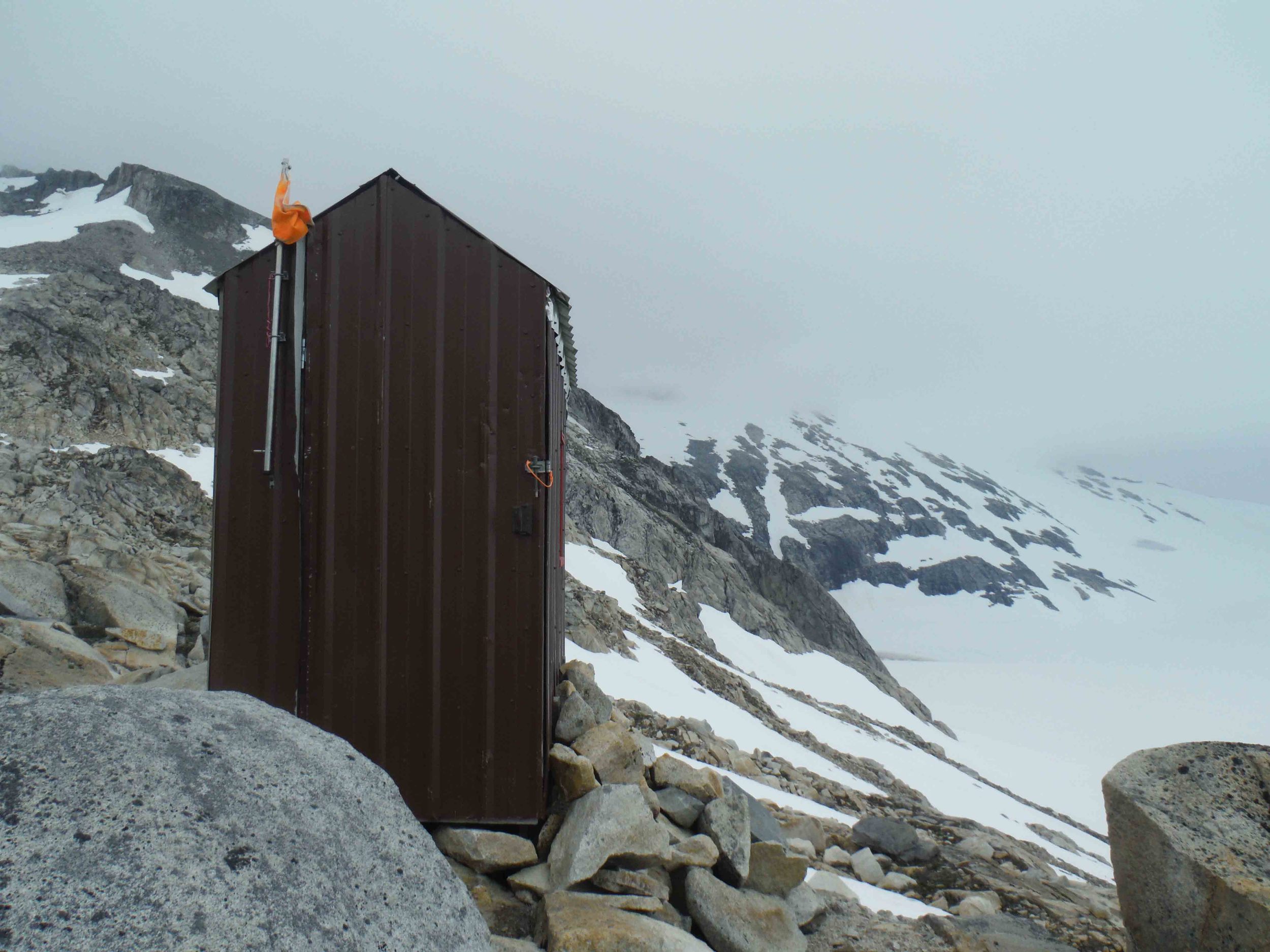
Without fail, whenever I give a presentation about Antarctica to school kids, there is always some cheeky little boy who raises his hand and asks, “How do you poop?”. Mind you this question never gets formally asked by a more mature audience; however, I know they are all thinking it. So here is the answer to the question of all questions you have been wondering about your loved ones or children: "How are they going to the bathroom?”. While the facilities may not be five star, they are more than adequate and very sanitary. They are cleaned thoroughly everyday and handwashing stations are used religiously. The early morning busting bladder wake up call is alleviated with a most glorious view, a far more grander experience than having the luxury of carpet on your walk to the royal throne room. Let my picture diary explain what words can not.
[NOTE: Click on any of the images below to open a slideshow with all photos and captions.]
Interview by Salvatore G. Candela
Dr. P. Jay Fleisher is a Distinguished Teaching Professor, Emeritus at State University of New York, College at Oneonta, where he taught Glacial Geology and Geomorphology. Jay has been involved with JIRP since 1968 when he participated with 15 other post-docs, and again on multiple occasions as a volunteer faculty member. Jay served as JIRP's Interim Director from 2010 through 2011, then returned to Camp-10 as teaching faculty member in 2013 after a one year hiatus.
Dr. Fleisher explaining the xenolith inclusions near Camp 10. Photo by Jamie Bradshaw.
P. Jay Fleisher: As is true for many youths, it is possible to be influenced by a single teacher or mentor, and the influence came for me when my general science teacher in 5th or 6th grade took us to a university where we toured the engineering facilities and got to see presentations by the faculty. I was so impressed by what these people did that I knew I wanted to be a scientist or engineer. During my first semester in an engineering curriculum I took a mandatory geology class that seemed to deal with topics of special interest. As I found myself learning about the formation of rocks and the Earth, I questioned “How could I possibly not study this?”. As I read the text books and listened to lectures I became so attached to the subject, and felt a passion for it, which lead me to become a geologist.
SC: What is your current field of study and interest?
PJF.: While in undergraduate school I found an introduction to a book on
metamorphic rocks that said “the best geologist is the one who has seen
the most rocks”. This inspired me to leave NY once finishing my
undergraduate degree and head to North Carolina for my Masters to “see
more rocks”. From there I headed to New Mexico to see even more rocks,
and continue to grow my own knowledge on the topic. While working there,
I realized I needed a PhD to do what I really wanted to do, teach at
the college level. While in graduate school for my PhD, I decided to
study glacial geology.
SC: What would you say was your greatest contribution to the world of science?
PJF: To have mentored and inspired undergraduate students to become scientists.
SC: What are the best and worst places your work has taken you?
PJF: The best place isn’t a place, it’s an environment, and the
environment is the glacier wilderness, examples include the Juneau
Icefield and Bering Glacier, Alaska.
The worst place….(long pause), was where I experienced being wet and cold, the combination being very physically uncomfortable, such as on the Juneau Icefield, and the Bering Glacier, Alaska, as two examples. Getting through these are also the experiences I take the greatest pride in.
SC: How did you become involved in JIRP?
PJF: While on the faculty at SUNY-Oneonta, I reacted to a mailed flyer
that described the JIRP program and applied and was accepted in 1968.
This was during my post-doc research. When I got here, I realized that
this was a place I could learn a lot about glaciers and glaciation, but
also a place where I could learn at least as much, if not more about
myself, thanks to the constant challenges presented in this environment.
SC: How has JIRP inspired your work or research direction?
PJF: While on a traverse across the Juneau Icefield, having traveled for
two days in a storm including a bivouac on the glacier, my small field
party of five were being transported on the back of a Thiokol (a large,
tracked, over-snow vehicle) to a permanent camp site. As I sat there,
watching glaciated mountains and glaciers slowly pass by I realized this
is a place that deserves my full attention, because it’s an analog for
what occurred in my home state of New York 14,000 years ago... I was
actually living in an ice age.
SC: As a scientist and former JIRPer, what role do you envision JIRP playing in shaping the coming generations of scientist?
PJF: Hundreds of young men and women were exposed to the Juneau Icefield
under the direction of Dr. Maynard Miller, the founder of the program. Looking
back, I see from the roster of all those who participated, the names of
some of the most outstanding scientists in glaciology and glacial
geology today. Knowing that JIRP launched them and myself into our
careers, I look towards JIRP to do the same for many more in the future.
SC: What advice would you give to the coming generation of young scientists?
PJF: Follow your bliss, never stop questioning, and never stop challenging yourself.
SC: Thank you very much for coming to the Icefield to teach us this year, and allowing me the opportunity to interview you.
Jay would enjoy hearing from those who have benefited from this blog: fleishpj@oneonta.edu
By Dr. Cathy Connor, University Alaska Southeast, Environmental Science Program,
The 2013 NASA Alaska Space Grant awardees are (from left to right) Jamie Bradshaw, Grayson Carlile, Patrick Englehardt, and Jonathan Doty. Not pictured: Sarah Mellies. Photo by Adam Taylor.
Through ASG’s Higher Education Program, I have applied for and secured summer funds to support students as they experience the glacier and earth science that occurs through JIRP. As UAS Affiliate Space Grant Director as well as a board member of the Foundation for Glacier and Environmental Research (FGER, the nonprofit organization that supports JIRP), I have been able to support over 70 undergraduate students in their JIRP experience, so critical to training the U.S.’s future climate scientists. JIRP recipients of this award have been able to fulfill the goal of the ASG’s Higher Education Program to contribute to the development of the science, technology, engineering, and mathematics (STEM) workforce in disciplines needed to achieve NASA's strategic goals.
On the basis of their academic achievements and financial need JIRP students are selected each summer with priority to Alaskan students. The 2013 awardees are:
Jamie Bradshaw, Grayson Carlile, Jonathan Doty, Patrick Englehart, and Sarah Mellies.
Previous NASA-JIRP awardees are now well into their successful professional careers as glaciologists, chemists, hydrologists, geodynamicists, engineers, and climate researchers. They include Dr. Shad O’Neel 1996 (USGS Glaciologist and FGER Board), Dr. Erin Whitney 1996 (Chemist-National Renewable Energy Lab), Dr. Joan Ramage 1997 (Associate Professor of Remote Sensing, Lehigh University), Hiram Henry 1998 (Alaska Department of Transportation), Matt Beedle 1999 (Doctoral Candidate, University of Northern British Columbia, FGER Board), Eleanor Boyce 2001 (UNAVCO), and Seth Campbell 2007 (Doctoral Candidate, University Maine).
By Stephanie Streich
This week, I had the opportunity to take part in two different glacial surveys to better understand the nature and changing characteristics of the Taku Glacier, located in the backyard of Camp-10.
The first surveying activity was the monitoring of the surface elevation of Taku Glacier, to track its pattern of growth and deflation. The monitoring of this part of the icefield has been one of JIRP’s long-running projects, and has contributed to a thorough record of this section of the ice. On this occasion, German surveyor Christian Hein and I traveled by snow machine across Taku Glacier to the same locations that are measured every year with a global positioning system (GPS). Upon reaching the approximate location of each waypoint, while carrying the GPS receiver, antenna and data logger, I walked around the snow machine to find the exact coordinates of the waypoints. Once the points were found, an elevation could be determined by holding the GPS antenna a fixed distance above the ground. This continued throughout the day until all the data for the waypoints were collected (approximately 40). Not only did I learn about the techniques used in the surveying, I was able to appreciate the tedious process of maintaining a record of the health of a glacier. On another note, I was surrounded by a gorgeous landscape that I do not have the privilege of seeing in my every day life, at the University of Alberta.
On my second day of surveying, I went out on the icefield with my former University of Alberta professor, Jeff Kavanaugh, and University of Alaska Southeast professor Jason Amundson to undertake the fieldwork required to monitor the movement of an area of glacial ice on the Taku. During this time, we set up a grid of predetermined GPS coordinates with nine wooden stakes that were jammed into the snow. Once the grid was established, a GPS antenna was placed on each of the stakes for a half hour to procure their exact locations. The height of the poles were also measured to monitor the rates of snow ablation, or melt. Jeff intends to revisit these sites two more times before we leave Camp 10 to obtain their GPS coordinates to eventually calculate the surface velocities of the moving ice.
Stephanie Streich by a GPS antenna, mounted to one of the strain gauge stakes. Photo by Jeff Kavanaugh.
As a student that had not done much field work in the past, participating in JIRP has made me appreciate working in the field in a way that I did not value in school. In a university setting, I learned about field work through the presentations from my professors and in my labs. However, learning about fieldwork and actually applying it in real life are two different things. For example, the presentations that Jeff delivered in class did not come near to actually experiencing what he does as a professional. In class, field work felt like a strict, rigid, process, which can be attributed to the stressful environment of university academia. Instead, I was pleasantly surprised to find out through experience that the work I was doing with Jeff was fun, insightful, relaxed and made me want to know the results of our tests. This is a message that I want to stress: that without participating in JIRP, I may never have known that science does not have to be a rigorous, structured activity in a stressful academic environment. I had lots of fun during my two field trips and hope to do more as the program continues into August.
By Sarah Bouckoms
Inspired by Salvador G. Candela
So you want pizza for dinner? So do we at Camp 10, but it's not as easy as calling up your favorite local pizza joint and handing over $20. There is a lot more love that goes into making pizza on the Juneau Icefield. Let my pictures explain.....
[NOTE: Click on any of the images below to open a slideshow with all photos and captions.]
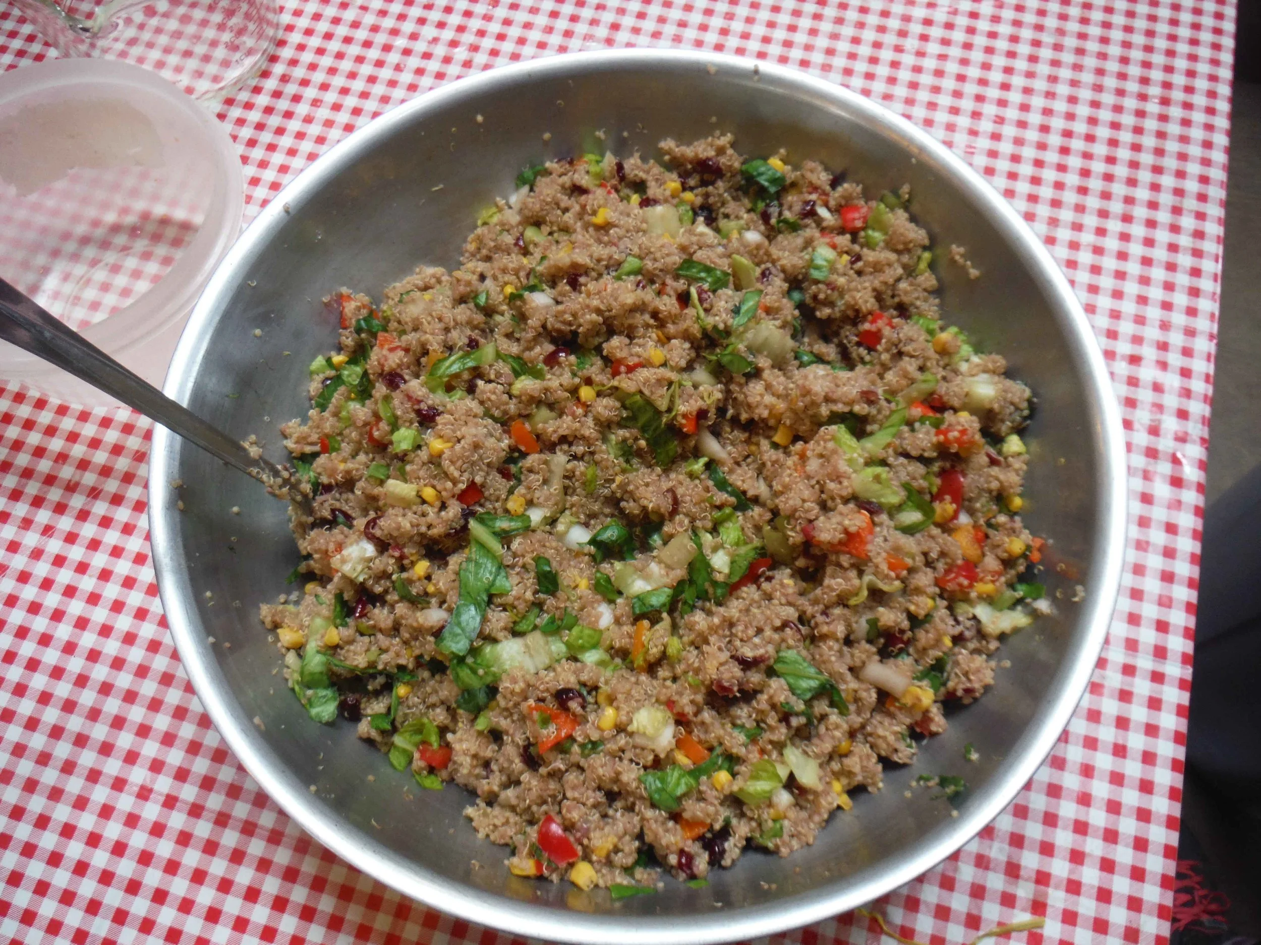
This meal was made for 32 people, since 10 were out on an overnight trip. All total we made six pizzas with 15 pieces each, and the quinoa salad to ensure everyone was full. Brownies are always a welcome addition to any meal on the Juneau Icefield. If that seemed like fun, imagine what it's like cooking for the full camp of 42! Bon Appetite from the 2013 JIRPers!
By Stanley Pinchak
For many years, JIRP has maintained year-round digital temperature measurement at several camps located across the Juneau Icefield. Starting in 1986 with the first installation in the Camp 17 Metshelter, the program expanded in subsequent years to include six camps which range from the most coastal, Camp 17; the most mainland, Camp 26; the mildest, Camp 10; and the highest and coldest, Camps 8 and 25. These camps string out along the route that the Program follows each summer, although not all students spend time at Camp 25 or Camp 8.
The original temperature loggers were graciously provided by long time JIRPer Robert Asher. These Ryan Instruments TempMentor (RTM) devices provide the ability to collect temperature readings every other hour for over a year. The RTM devices are sealed inside of hard plastic lunch boxes and after 1987 were modified with a sealed port for the external temperature probe. These recording devices have been installed in the Stevenson Meteorologic Shelters (Metshelters) at the various camps alongside other meteorological instruments.
Robert Asher performing routine maintenance on RTM at Camp 8 in 1987. Photographer unknown.
A newer series of temperature loggers from Pace Scientific have been donated by Robert Asher and Analytical Research Associates. The standard Pocket Logger provides the ability to capture two years of hourly temperature recordings. This provides the possibility of capturing usable data even if logistics or computer issues prevent data recovery the year following deployment. Other benefits of the Pocket Logger include finer temperature resolution, the ability for pre-set deployment, a report format that includes date/time information corresponding to a particular measurement, and the ability to interrogate the device to check status while in operation.
Camp 8 Metshelter housing temperature sensors. Photo by Alf Pinchak
While many JIRPers have been involved in the installation, maintenance, and collection of data from the temperature loggers, Alfred Pinchak has been involved since the beginning and remains the primary force in making sure that the JIRP Temperature Project (JTP) continues to collect data. He is instrumental in training JIRP students and staff who have accompanied him while he makes the tour of the camps each year.
Alf Pinchak at Camp 10 alongside one of his beloved Metshelters. Photo by Sarah Bouckoms
Due to time constraints in recent years, Alf will often travel by snowmobile ahead of the main JIRP program to reach the more distant Camps 8, 25, and 26. The blitzkrieg of the farther camps is a rather exhausting task. Not only must last year’s data be downloaded and the loggers be deployed for the upcoming year, there are calibrations which must be performed and recorded, maintenance of the Metshelters, and preliminary camp opening tasks are also performed at this time.
Camp 17 Metshelter under repair. Photo by Alf Pinchak
This year Alf was able to collect the data from Camps 17 and 10 while he traveled with the main Program. He elected to send Scott McGee and Stanley Pinchak on to the remaining camps. Scott and Jeff Kavanaugh had reported earlier in the summer that the Metshelter at Camp 18 had gone missing, and in order to ensure adequate time to locate or replace it, a two day trip was planned. Weather permitting, Scott and Stanley would leave and perform their tasks at Camp 18, 8, and 25, sleeping at Camp 18 and then travel to Camp 26 the following morning.
On the day of departure, the weather was excellent for snowmobile travel and the plan was slightly altered. After departing Camp 10, Scott and Stanley headed immediately to Camp 8 and had a rather uneventful time after Scott found safe passage across the crevasse that extends down the southern slope of Mt. Moore. Machining off under a reddish late morning sun, the result of recent forest fires in the region around the Juneau Icefield, the two headed to Camp 18 to pick up additional gas and to make an initial survey of the area around the missing Metshelter, uninhibited by the whiteout which had made this impossible for Jeff and Scott just a week earlier. While the legs of the Metshelter were thrown off their moorings, only a few splinters of the Metshelter could be located in this initial survey.
The Metshelter at Camp 8 with Mt. Moore in the background. Photo by Stanley Pinchak
With the gas having been procured, Scott directed the snowmobile past the 8-18 junction and the Blob on towards Mt. Nesslerode and Camp 25. The initial Eastern approach was complicated by crevasses and blue ice which limited access to the base of the camp. A wide swing around the crevasse field allowed an alternate approach from the Southwest. The steep climb over rock that looked like fractured shale was complicated by soft sand, the result of weathering and erosion. Each footstep was seemingly more treacherous than the last, every weight transfer the opportunity for the underlying media to give way a little or a lot. From initial appearances, the Metshelter appeared to be in pretty good shape, despite still needing a good coat of flat white paint. Upon opening, it was apparent that something was amiss. There were two data loggers in the Metshelter, but only one probe was secured inside, the other sensor was missing. Further investigation indicated that the plastic probe holder fatigued, failed, and fell, allowing the probe to slip through the ventilation holes in the bottom of the shelter, leaving it hanging, exposed to daytime solar radiation.
After the initial disappointment caused by this hardware failure that has possibly biased some unknown portion of the daytime data, the task of recovering, calibrating, and redeploying the Pocket Logger commenced. All was going smoothly until it came time to change the batteries on this newer model Pocket Logger. For reasons still unknown, the device would not communicate for redeployment and after a period of time spent in troubleshooting and testing with a backup device, it was decided to install the backup for the upcoming year. Unfortunately, this would limit recording to every hour as compared to the newer device which was capable of recording every 15 minutes. Additionally, deploying the backup recorder would leave Camp 18 without a logger in the event that the Metshelter or its contents could not be found. Some small maintenance was performed on the Metshelter, including the installation of barrel latches to secure the door and re-installation of the temperature probe.
When they had completed their work at Camp 25, Scott and Stanley headed back toward the main branch of the Llewellyn Glacier and then Northward to Camp 26. The mid-afternoon approach to Camp 26 was complicated by the swamp of super-glacial streams, blue ice, small patches of snow, and moraine material that dominate the glacier for the kilometer between the C-26 Ski Hill and Toby's Rock. Scott managed to plot a course through this quagmire that brought the snowmobile to the base of Toby's Rock. The hike up and around to picturesque Camp 26 was punctuated by the songs of the marmots and accompanied by the burbling of mountain streams and occasional drone of flying insects.
Author Stanley Pinchak takes temperature readings from the swamp in super-glacial streams en route to Camp 26. Photo by Scott McGee
It was soon discovered that all was not well with the Camp 26 Metshelter. The door stood open, a securing bungie cord hanging loosely, longing for its missing companion, the data recorder. In disbelief, Stanley and Scott wondered aloud what might have caused such a situation. Was it vandals or thieves, or something more sinister like marmots? No those did not make sense since there remained the second recorder unmolested. It could only be the wind. That cold, cruel force that seemed to be wreaking havoc across the Icefield this past year must be to blame. Fortunately, the data logger was discovered about 10 meters down slope, protectively encased in its plastic lunchbox, merrily recording “LO” for who knows how long. Its temperature probe was located nearby, severed and lacerated in a dozen places, the result of the fall on the rocks or of marmot teeth could not be ascertained.
The Metshelter at Camp 26 was left exposed to the beautiful views. Photo by Stanley Pinchak
After a hard day’s work the RTM is going nowhere in its home at the Metshelter of Camp 26. Photo by Stanley Pinchak
After the RTM data was recovered, the probe replaced and the device calibrated and redeployed, work commenced on creating a more secure solution than the single bungie which had long since seen more elastic days. A couple of new bungies were employed, securing the RTM to newly installed anchors. The door to the Metshelter was also secured with some wire to prevent future wind related mishaps.
While at Camp 26 it was discovered that the newer Pocket Logger had decided to begin talking to the computer again. With this welcome news, the plans for the next day changed slightly. Before heading to Camp 18, another stop at Camp 25 was scheduled to recover the spare logger and install the device that regularly monitors that camp. A warm night was followed by a sunny but again slightly hazy morning. The marmots again performed as Scott and Stanley cleaned up the plywood explosion, handiwork of wind and marmot, before heading to the snowmobile. On the way up and out of the glacial marsh, temperature data was collected at two small super-glacial streams in the hopes of gaining further insight into the characteristics of the water systems that permeate the temperate glaciers of the Juneau Icefield.
A long drive from the upper reaches of the Llewellyn ablation zone to Mt. Nesselrode was followed by a quick stop at Camp 25. Swapping out the recorders allowed for another opportunity to play “don't drop the equipment” as Scott and Stanley negotiated the increasingly longer hike from the top of the glacier to the kitchen and Metshelter of Camp 25, a byproduct of years of negative mass balance since the creation of the camp. The weather remained clear and the views from Camp 25 to Camp 18 were breathtaking.
Upon arrival at Camp 18, the search for the missing Metshelter began in earnest. Initially the edges of the snowfield immediately South of the Metshelter were combed, then a larger sweep began when this proved unsuccessful. Outhouses and other sheltered locations were checked in the event that researchers from the USGS had discovered the Metshelter and moved the equipment earlier in the season. This too proved unfruitful. As Scott worked the Western reaches of the Camp 18 outcropping, Stanley headed South. Finally, it was heard from the South, “SCOTT, I've found it!”
Scott McGee searching for missing instruments at Camp 18. Photo by Stanley Pinchak
The remains at Camp 18 after the wind had its way with the Metstation. Photo by Stanley Pinchak
There they were, the splinters and pieces of a large Stevenson Metshelter, spread out vertically along perhaps 15 meters of stair stepping cliffs, which start with an initial four meter drop, and located Southward about 75 meters from the original location of the Metshelter. Among these shattered remains were some of the instrument contents of the Metshelter and hints at the fate of the others. Holders for the high/low thermometers were found along with cracked pieces of a blue pelican case, evidence of massive trauma with bare rock written on its surface, a bag of desiccant placed alongside the Pocket Logger in its case was found among the wooden splinters. While the hopes for the Pocket Logger and its data were dashed, there was still hope for Scott's instrument. Unfortunately, the search was called off after a thorough investigation of the rocks near the remains of the Metshelter and the edges of the snow field which extends below these rocks proved unsuccessful.
The temporary Metshelter at Camp 18 all rocked in to support it against harsh winds and marmots. Photo by Stanley Pinchak
With the mystery of the missing Metshelter having been discovered, work began to install a new temporary Metshelter in preparation for a new recording year. A new site was located and legs were rocked in, a temporary anchor until the Program arrives at Camp 18 and more permanent cable ties can be installed. A smaller, more aerodynamic Metshelter was attached to these legs and readied for the upcoming year. The only problem was that the Camp 18 Pocket Logger was missing, assumed destroyed in the catastrophic events of the previous year. Worse, the weather resistant case was also missing and in any event, damaged heavily in the fall. How could the JTP continue at Camp 18?
The spare Pocket Logger and a super-glacial stream temperature probe were the answer to the question posed by the first problem. All that remained was the weather proof case. A plastic peanut butter jar procured from the generator shed provided the weather proof case, the damaged probe taken from Camp 26 provided the sealed port for the new probe. A little silicone here and there and the JTP was ready for another year at Camp 18. After using the tired old bungie from Camp 26 to secure the door to the Metshelter, Scott and Stanley headed back to the Nunatak Chalet arriving just in time for dinner. A tale of highs and lows, of beauty and exhilaration, of despair and hope completed. Another Tour de Alf for the record books.
A new protective housing was FGERed out of a peanut butter jar to ensure the science continues! Photo by Stanley Pinchak
By Grayson Carlile
Since our arrival at Camp 10 we have shifted gears from safety and expedition training to science . Our time has been spent developing our individual research projects and receiving lectures from an exceptional group of faculty. We are beginning to delve into the details of how the icefield functions.
So before we begin filling the blog with our research and theirs, we thought it appropriate to give a brief explanation of what a glacier is - how snow is transformed into the spectacular rivers of ice that we are wandering among this summer.
The rivers of ice we know as glaciers form from the accumulation of enormous quantities of snow. Mendenhall Glacier, Alaska. Photo by Adam Taylor
It all starts with the same snow you might have falling in your backyard during the winter. Most of us, however, do not have glaciers in our backyards, so there must be a few other criteria. Here is where snow quantity and local climate come into play. There has to be enough snowfall that summer temperatures will not melt it all away before the snow returns. Some of the snow that has accumulated has to persist through the entire year.
Then the process has to repeat itself...over, and over, and over again. As time goes on, individual snowflakes begin to metamorphose – their delicate, spindly structures gradually breaking down through a combination of melting, refreezing, and pressure from overlying snow. The resulting products are rounded ice granules called
firn. In the final step on the journey to becoming glacial ice, these firn granules meld into larger ice crystals that fit together like pieces in a three dimensional jigsaw puzzle.The transformation of snow to glacial ice can take decades to centuries depending on the consistency (wet or dry) and quantity of snow that falls. Once the ice has formed, it can begin to take on the properties of a glacier. As mentioned above, glaciers are rivers of ice. By definition they are moving - pulled downhill by the force of gravity. So in order for the ice to become a glacier, something has to change within the ice in order for it to flow.
Once the ice is a few tens of meters thick, there is enough stress on the underlying ice that it begins to behave viscously - that is, similar to a fluid - and can finally deform and flow. To understand how this works, imagine a ball of silly putty. If you work it in your hands, applying pressure, you can get it to start stretching and slowly flowing. This is essentially what happens to the underlying ice in the 70 meters of accumulation. The pressure of the overlying ice brings it to a consistency that allows it to flow. Once it has reached this point, it begins to succumb to the force of gravity and flow down a valley or across a continent. In addition to this viscous flow, some glaciers such as those that exist in warmer climates, may also flow over the bedrock or sediments at their bases.
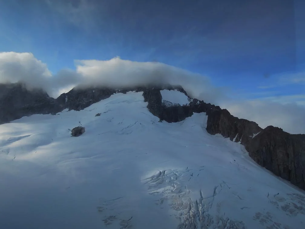
So while a reference to glaciers may conjure images of the Arctic or Antarctica in the minds of many, with the right conditions glaciers can form almost anywhere – from the summit of Mt. Kilimanjaro in Africa, to the South Island of New Zealand, to the Cascade volcanoes of Washington State. However, glaciers can and do behave differently in these various locations. Some places, such as Southeast Alaska, where precipitation and cool temperatures are widespread and rampant, cater to more than just a single glacier, producing complex networks of glaciers such as the Juneau Icefield. Here the Coast Mountains receive more snow than almost any other place on Earth. The vast distribution of enormous quantities of snow has created nearly 1500 square miles of glaciated terrain that drains the rugged mountains – flowing east into British Columbia and west into the salty waters of Alaska’s Inside Passage.
By Mary Gianotti
[NOTE: Pictures will be added to this post when they are available.]
One of the main safety hazards in crossing the Juneau Icefield is that posed by snow-covered crevasses. Crevasses are cracks in the surface of a glacier caused by stress from moving ice, and vary in depths up to many tens of meters. They often occur at the edges and lower extents of glacier, at the outside of bends, and areas where the glacier surface steepens. Given that even the safest route takes us through some crevassed regions, JIRP field parties rope up into groups of four or five team members and move in unison. In the event that a team member falls into a crevasse (which has rarely happened on the icefield!), JIRP trains students to implement the Z-pulley system. This system uses a simple set of tools: a climbing rope, a few loops of cord or webbing (called slings), sit harnesses, and a small number of carabiners. Additionally, skis and ice axes are used to build a safe anchor, which can be used to haul the team member to safety. The system is efficient and lightweight.
To simulate a rope-team member falling through the snow into a crevasse, we took turns dropping off of the moat’s lip. Immediately, all other group members dropped into the self arrest position, securing themselves to the snow with their ice axes and bodies to stop the fall. The first order of business is to communicate with the victim: Are they alright? Do they need medical attention? Can they climb out by themselves, or should we build a Z-pulley system?
After establishing the physical state of the victim and determining that they need assistance, the next task for those up on the surface is to build an anchor. A couple members hold the weight of the victim; this frees another member or two to begin digging an anchor. Fortunately, Alaskan snow is almost always wet, thanks to the wonderful rainforest climate of the region. It therefore provides a secure hold for the anchor: usually a pair of skis, clove hitched together by a sling and buried.
Once the anchor is completed, the rope is connected to the anchor using a sling, into which a special, friction-generating knot known as the “prussik” is tied. This sling is then clipped into the anchor with a carabiner. After this is accomplished, the weight of the victim can be safely shifted to the anchor. Other team members can also clip into this anchor, either directly or by securing themselves to the climbing rope via another prussik. This allows the rescuers freedom to safely move about, check on the victim, and, if possible, prepare the lip of the crevasse (by knocking off snow, if safe, or putting an object under the rope so that it doesn’t cut deeply into the snow). Ideally, a team member stays at the crevasse’s lip to monitor the victim.
Now it is time for the rest of the members to set up the Z-pulley. The system is named this because the rope is folded back onto itself like the letter “Z” using additional prussiks and carabiners. This arrangement provides a 3:1 multiplier in force – thus making rescue of the victim possible.
We first built the Z-pulley in one of the biuldings, then outside in the sunshine, and then in an icy rainfall that was blowing sideways. Students practiced being at all positions of the rope line. We all lead the team at one point or another. We worked through nearly every possible scenario until we came up with a solution. “Mr. Backpack” and other inanimate objects were great at being non-responsive dead weights. Sometimes, unknown to the pull team above, the weight of one person in the moat secretly became that of three, as others joined in to challenge the haulers and test the system.
So as of now, we feel ready to conquer any crevasse that dares to cross our path. I know now that crevasse rescue is an important tool for glacier travel. On our traverse from C-17 to C-10, there were times when we had to travel in rope teams over crevassed terrain and we crossed the areas with confidence and security. While there were lighter moments in our training, I trust my fellow expedition members to realize the gravity and weight of the situation if I fall into a crevasse and that they will pull me to safety.