The Secret Natives of the Juneau Icefield

By Ben Slavin

Many students and faculty take part in JIRP each summer with the central goal of using the Juneau Icefield as a living and breathing classroom of Earth system science. As a high school JIRPer in 2011, I imagined that I too would take part in the numerous exciting glaciological projects that have been ongoing since 1946. But as I began exploring the mountaintop landscapes, known as “nunataks”, of JIRP’s field camps, I realized that there was a whole other world waiting to be delved into. With the help of dedicated JIRP faculty member and geobotanist, Polly Bass, I gained my first experience in the field of glacial entomology by conducting a general survey of glacier flea (H. nivicola) population characteristics on the Taku Glacier in front of Camp 10.

After completing my project and closing the proverbial book on JIRP 2011, I returned to my senior year of high school assuming that I would only ever return to the Icefield in my countless wonderful memories. A year later, I watched my sister Lindsey complete the program as a high school student and, like so many of the individuals that make JIRP the juggernaut of a program it continues to be, I found myself longing to return to the High Ice. “But how?” I wondered. As I was sitting  in a biology class at the University of Miami (FL), where I am pursuing a degree in Neuroscience with the ultimate dream of becoming a medical physician, I remembered the fascinating glacier insects that I had studied two years prior through the lenses of a high school student. Now that I had a college level understanding of the field of biology, I was very hopeful that I might be able to apply this knowledge to the Icefield. After corresponding with Polly, JIRP Director Jeff Kavanaugh, as well as Dr. Sean Schoville at the University of Wisconsin Madison, I was thrilled to be informed that I would have the opportunity to return to JIRP to study insects once again.

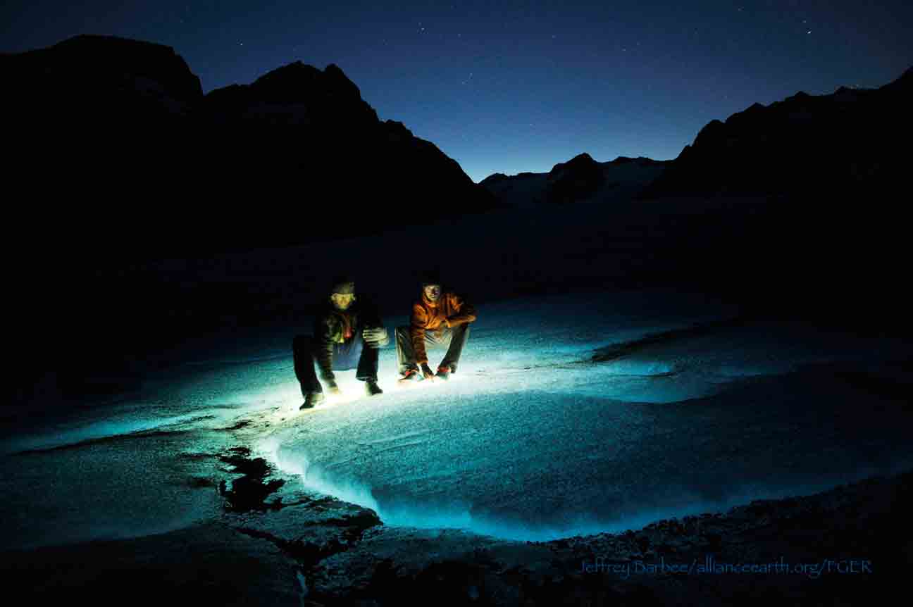
Ben Slavin night-collecting N. lituyae.  Photo by Jeffrey Kavanaugh.

Instead of glacier fleas, the research project I am taking part in this summer focuses on a species of beetle known as Nebria lituyae. This species is very near and dear to the Kavanaugh family given that Jeff’s father, Dr. Dave Kavanaugh, discovered and named the species and Jeff himself has been collecting it for his father from a young age. The central goal of the project is to determine the amount of microevolution, also known as evolutionary diversification within a species, that is occurring between populations of Nebria lituyae on various nunataks located all over the Icefield. When my friends and family, many of whom are Florida natives, who are much more familiar with sandy beaches than they are with snow and mountains, asked how we were expecting to go about determining microevolution amongst beetles, I cited Darwin’s classic expedition to the Galapagos Islands.
Darwin observed with finches in the Galapagos that being reproductively isolated from their mainland conspecifics caused the island finches to have different physical appearances from finches on the nearby South American continent. Darwin wrote that he believed that the Galapagos finches’ separate gene pool favored individuals who were best suited to surviving the Galapagos’ unique environment over many generations, thus explaining the difference in physical appearance. Essentially, it helps to think of each mountaintop nunatak as its own island, surrounded by a sea of snow and ice instead of water, the target of our collection trips to each of these “Icefield Islands” is not finches but N. lituyae beetles, with the hypothesis that there has been a level of microevolution that has occurred amongst the isolated populations.

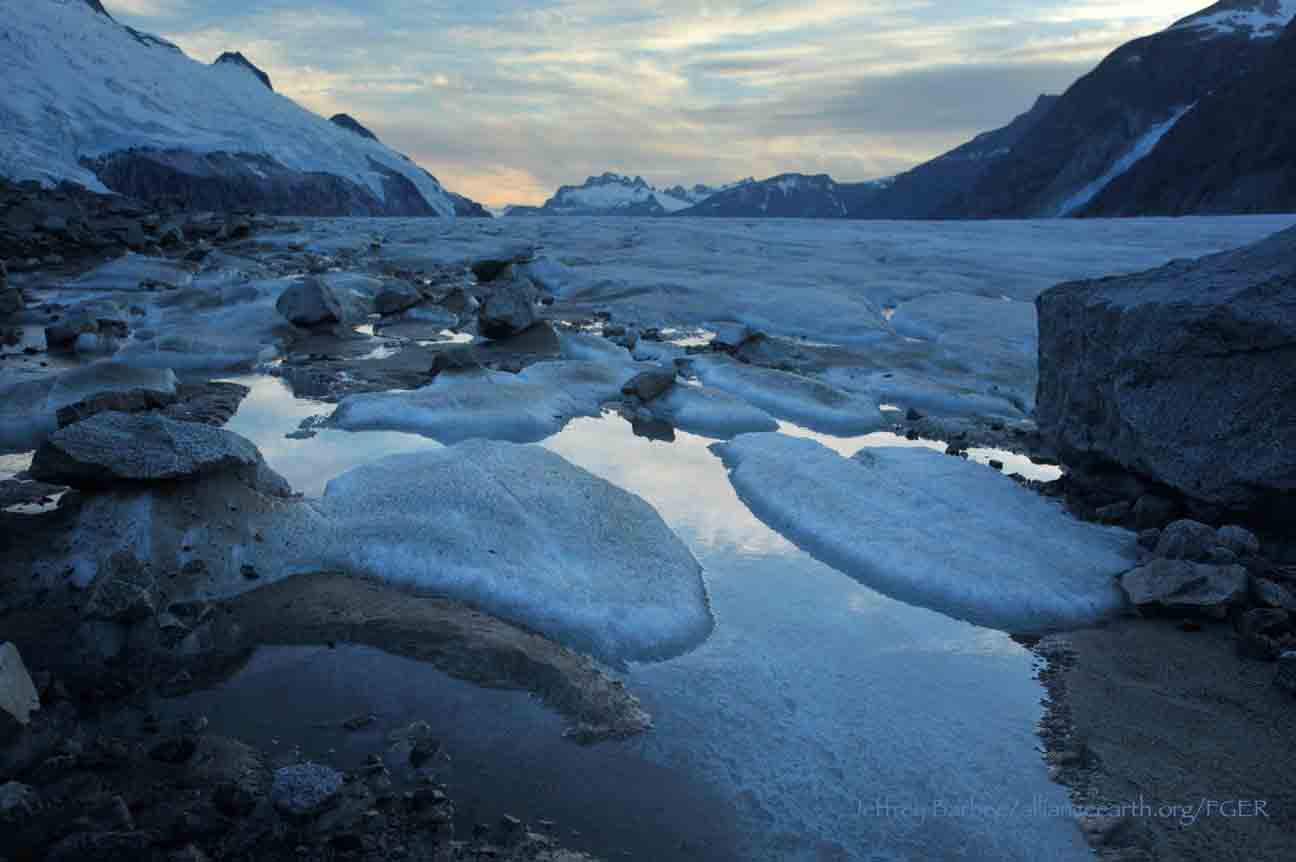
In order to be able to study and compare N. lituyae beetle populations, Jeff, Polly, and I (as well as Staff Member Scott McGee, faculty member Gabrielle Gascon, fellow student Pat Englehardt, and Field Safety manager Adam Toolanen), have ventured out on numerous collection trips to strategically-spaced nunataks in which we gather the beetles and humanely preserve them in alcohol-filled collection vials. The biggest challenge of these daytime collection trips thus far has been finding the beetles, which are most active at night when they venture onto the snow bank to feed on other insects that may have died during the day.  Given the beetles’ penchant for darkness, daytime collection trips mean that we must turn over (and then carefully replace so as not to disturb the ecosystem) many rocks at each nunatak site we visit. Further adding to the challenge is that we must find a minimum of ten beetles at each nunatak in order to be able to compare them to other nunataks. Some days, we are unable to meet the minimum requirement of ten beetles collected and must don our headlamps for a collecting session after nightfall, when the N. lituyae are much easier to spot. Though the “ten beetle rule”, can lead to some longer days in the field, I personally have been relishing the opportunities to explore cool spots, like the base of "Taku B" behind Camp 10, after dark. 

Ben Slavin collecting at Shoehorn Mountain, across the main branch of Taku Glacier from Camp 10.  Photo by Jeffrey Kavanaugh. 

The reasoning behind a minimum of ten beetles from each nunatak is that we must allow for a certain degree of variability amongst individual beetles that come from the same nunatak. For example, my sisters, Lindsey and Blaire, came from the same parents and grew up in the same environmental conditions I did, but our DNA sequences are not the same as is evidenced by our many physiological differences, such as height. 

After explaining the mechanism behind microevolution as well as the collection protocol, my Floridian friends and family are usually eager to learn exactly how we intend to go about determining if microevolution is indeed occurring amongst the N. lituyae populations of the Juneau Icefield. Once we have collected all of our samples for the field season, the beetles will be sent to the lab of Dr. Sean Schoville at the University of Wisconsin Madison. In his lab, Sean will use a specialized technique to surgically remove a part of each of the beetles we collect. Sean will then be able to extract a specific DNA sequence from each beetle which will be compared to the other beetles found on the same nunatak, as well as different nunataks.

We hypothesize that given the beetle populations’ isolation from each other,  these DNA sequences will be somewhat different from one another. We are also taking global positioning system (GPS) readings at each of the nunataks where we collect so that we will be able to see if differences in DNA sequence between N. lituyae populations correspond with the distances between the nunataks from which they are collected. Of course, there is also a chance that the DNA sequences of all of the N. lituyae populations will be the same. This would also provide an interesting result as it would suggest that the N. lituyae populations are able to move from nunatak to nunatak in spite of the extremely harsh conditions of the Juneau Icefield.

Regardless of the findings of this riveting project, I have been having the time of my life rediscovering what made the Juneau Icefield Research Program something special for my father, Andrew Slavin (JIRP ’73), who raised me with whimsical stories of this magical place in Alaska. Aside from the amazing landscapes and mostly beautiful weather, I’d have to say that my favorite thing about this program continues to be the people. When I first joined the group, I was equally excited to be reunited with old friends as well as make many new ones, and I most certainly have. I have definitely appreciated how enthusiastic everyone has been about my project - I don’t think a single insect, let alone beetle, has walked through camp without someone letting me know of its whereabouts.  The group of students, staff, and faculty who choose to truly take the time to enjoy each others’ presence while doing great research on the Icefield is truly what has made JIRP one of the most special times of my life now not once, but twice!

Geomorphology of The Cleaver

By Patrick Englehardt and Leah Nelson

Camp 18 is located on a body of exposed rock called the Cleaver, and it is bordered by the Vaughan Lewis and the Little Vaughan Lewis icefalls. Although it currently stands proud of these icefalls, it is clear from geomorphological evidence that the Cleaver was once overridden by glacier ice. The scarred rock left behind following glacial erosion can indicate the direction of ice flow and can give clues to help understand subglacial conditions and forces.

Geomorphological features found on the Cleaver include chatter marks, striations  and roche moutonnee (all of which are defined below). Leah Nelson’s project is the creation of a geomorphological walking tour on the Camp 18 nunatak that identifies these features for future generations of JIRP students. The following photos and definitions are part of this project.

Chattermarks: Chattermarks are a series of small and closely spaced crescent-shaped features made by vibratory chipping of the bedrock surface by rock fragments carried in ice at the base of the glacier.  Their shape indicates movement; they are generally convex in the direction of ice motion.  The bedrock of the Cleaver is littered with chattermarks, showing the movement of the overriding ice.  

Chattermarks in the bedrock of the Cleaver.  Photo by Leah Nelson

Striations: Striations are multiple scratches, often parallel, inscribed on the bedrock surface.  These are caused by the sediment load in the base of the glacier that scraped along the bedrock.  In some places on the Cleaver, you can see striations that pass through both the bedrock and inclusions that are of a different rock type.  This instance of differential weathering shows the contrasting resistances between the two types of rock due to their composition.

Striations through a xenolith. Photo by Leah Nelson.

Roche Moutonnee: A roche mountonnee is an elongated bedrock knob whose long axis is oriented in the direction of ice movement. The upstream side is gently inclined, smoothly rounded and striated; while the downstream side is rough and steep, often with portions of rock removed or plucked away during formation. The term comes from the French and means “sheep-backed rock”.

Author Leah Nelson gives scale to a roche mountonnee on the Cleaver. Photo by Patrick Englehardt.

Author Patrick Englehardt stands on another roche mountonnee with the impressive Gilkey Trench in the background. Photo by Leah Nelson.

Gilkey Trench Fieldwork Adventure

By The Gilkey Trench Crew (Jamie Bradshaw, William Jenkins, Jon Doty, and Justyna Dudek)

While many students already started the fieldwork for their projects at Camp 10 and even Camp 18, five students have been anxiously awaiting to begin their fieldwork in the Gilkey Trench. The Gilkey Trench is the magnificent view that you see from Camp 18 where the Gilkey, Vaughan-Lewis, the Unnamed and many other glaciers connect and flow down through the steep, glacially carved, 2,000 foot deep valley. The Trench is filled with beautiful curving medial moraines and jaw dropping ogives created by ice falls. Getting to such a beautiful place is not easy and well worth a full day’s effort.

Descending "The Cleaver" - approaching the start of the series of fixed ropes - with the Gilkey Trench in the background.  Photo by Adam Toolanen

On Wednesday, July 31st, these students and four safety staff members departed Camp 18 for our camp on the bare glacier ice in the sunshine. The trick to getting to the glacier is descending what is affectionately called “The Cleaver.” The Cleaver is the 2,000 feet of bedrock that sits between Camp 18 and the glaciers below.  The descent was led by senior staffer Scott McGee, who has done the route many, many times. The first half of the route was going down steep snow slopes until we got to a vegetated area called “The Heather Camp.” This is where the fixed ropes began.

Waiting in a safe location - protected from rockfall from above - for their turn to descend the next section of fixed ropes.  Photo by Adam Toolanen. 

Here, the students and staff put on helmets and harnesses and tied into the fixed ropes with a knot called a prussik. This rope system served as a back up in case there was a slip on the steep, unstable terrain.  Fixed ropes were used for the last half of the descent because the route became steeper and more exposed. Because the glacier is melting, new bedrock and rock debris is left behind. This makes finding new routes difficult and challenging in the unstable footing. After 11 very long hours, the students and staff safely and happily arrived at our camp in the Gilkey Trench during a magnificent sunset.

Scott McGee scouts the lowest section of the descent made of freshly exposed bedrock, and precariously deposited boulders left by the rapidly thinning Gilkey Glacier.  Photo by Jeffrey Barbee. 

The next two days were spent collecting data from the field. A brief explanation of the students’ projects in the Gilkey Trench are below:

Jamie Bradshaw - Surface Ablation of the Gilkey Glacier

For my project, I looked at the ablation, or melt rates, of the Gilkey Glacier. In May 2013, wires were steam drilled into the ice for Dr. Anthony Arendt at the University of Alaska Fairbanks (also a visiting JIRP Faculty member earlier in the summer). My task was to find these wires and measure how much wire was exposed. Luckily the sites came with known GPS coordinates and had a wire tetrahedron with bright orange flagging attached to it, so it was fairly easy to find in the rolling, mildly crevassed terrain of the Gilkey Glacier. By knowing the length of the wire exposed at the time of installation (which I will find out upon returning to civilization) and measuring the length of wire exposed in August, the ablation can be determined. This becomes important because once the area of the glacier is known, the total amount of melt water runoff from the glacier to the ocean can be calculated.

Jamie Bradshaw photo documents one of the ablation-measurement sites on Gilkely Glacier.  As the glacier surface melts, more wire (at Jamie's feet) is exposed.  Photo by Jeffrey Kavanaugh. 

William Jenkins - Ogive Survey

My research in the Gilkey Trench was focused on the ogives, also called Forbes Bands, which form at the base of the Vaughan Lewis Icefall, adjacent to Camp 18. These interesting features in the ice are annual formations that only appear beneath fast flowing icefalls. It is commonly accepted that their light and dark banding represents the variations between summer and winter ice that has made its way through the icefall in one year. Summer ice, which is subjected to wind blown particulates and increased melt, constitutes the dark bands of the ogives and forms the trough of their frozen wave-like appearance. The white winter ice is composed of that year’s snowfall, and forms the crests of the wave bulges. 

William Jenkins surveys one of the Gilkey Glacier ogives with GPS.  "The Cleaver" is the ridge of rock in the background, with the Vaughan Lewis Icefall on the right.  Photo by Jamie Bradshaw. 

The purpose of my study was to determine how fast this area of the Gilkey Glacier was thinning in comparison to previous years. In order to determine this rate, I conducted a longitudinal GPS survey, with the help of Scott McGee, that had previously been carried out from the years 2001-2007. As a result of the glacier’s rapid thinning rate, I’ll be able to calculate its subsidence by the changes in the elevation of the survey over time. I will also compare the data I observe with the Vaughan Lewis mass-balance data that JIRP has collected over the years. This comparison will allow me to correlate the changes in annual precipitation with the transformations in the ogives wavelength and amplitude over time. The relationship between mass balance and ogive structure will shed light on the future transformations of the ogives and Vaughan-Lewis Glacier as a whole.    

Panorama of one of the ogives near the base of the Vaughan Lewis Icefall (in the background).  Photo by William Jenkins. 

Justyna Dudek - Photogrammetry

The main objective of my project was to create an up to date digital terrain model (DTM) of the Vaughan Lewis Icefall flowing down from Camp 18 into the Gilkey Trench. A digital terrain model describes the 3-dimentional position of surface points and objects, and can be used to retrieve information about geometrical properties of glaciers. In order to create the model, I decided to explore the procedures and tools available within the field of digital photogrammetry, a practical method which allows carrying out non-contact measurements of inaccessible terrain (very useful for areas such as icefalls, which for the sake of avalanches and falling seracs, might be too dangerous for exploration or measurements on their actual surface). The baseline dataset for creating the DTM of Vaughan Lewis Icefall  were recorded on the first, sunny and cloudless day of our stay in the Trench. With the guidance from Paul Illsley (present via radio from Camp 18) and help from my colleagues Jeff Barbee and Jon Doty (present on the Gilkey Trench), I set up the three profiles along which we collected the data in the form of terrestrial photogrammetric stereo pairs and ground control points (GCP). The database created by our team will be subsequently processed in order create a DTM which can constitute a reliable, starting point for further research in this area in the future.


Paul Illsley overlooks the Vaughan Lewis Icefall from a terrestrial photogrammetry station near Camp 18.  Photo by Mira Dutschke. 

Jon Doty - Nunatak Biology

My path into the trench followed a slightly different approach than the other students who reached the Gilkey Trench via the Cleaver descent.  Ben Partan – Senior Staff member in charge of camp maintenance – and I were brought down to the Gilkey via helicopter from Camp 18 to Camp 19, with a load of material to fix up the camp, which sees infrequent use. After two days repairing the roof, and siding, as well as swamping the camp interior, we descended into the trench. During our descent we made four stops at progressively lower elevations, conducting a botanical survey. At each site I recorded all plant species present, the compass orientation of the plot, elevation, and tried to keep an eye out for faunal interaction, and any other interesting features of the site. 

Ben Partan repairs the C 19 roof.  The upper Gilkey Glacier is in the background.  Photo by Jon Doty. 

As we dropped down closer to the surface of Gilkey Glacier - biodiversity plummeted. My final site featured only a single species of plant, as opposed to nearly twenty at the highest point of my survey. This loss of biodiversity can be tied to the recession of the Gilkey exposing new substrates, and the time required for mosses and lichens to reach the area and for soil to develop. Using a rough dating technique called lichenometry, we can gain insight as to the amount of time each site has been exposed by the recession of the glacier. The lichen species Rhizocarpon geographicum grows about 1 cm for every 100 years and is very common. Its absence at the lowest two sites is therefore noticeable, and signals that these sites were only recently revealed.

My survey is paired with another conducted by Molly Blakowski on the southerly oriented C 18 nunatak. These two slopes face each other with the Gilkey separating them. We plan on comparing the results of our surveys to determine what affects the differences of aspect have on the vegetation.   It was an absolute pleasure to join back up with the group and explore the Trench, and true fun to climb up the Cleaver and reunite with the rest of the JIRPers at C 18. 

The 2013 Gilkey Trench Crew (left to right): Jeff Kavanaugh, Jeff Barbee, Justyna Dudek, Jamie Bradshaw, Adam Toolanen, Adam Taylor, Jon Doty and William Jenkins. Photo by Jeffrey Kavanaugh

In closing, on August 3rd, the Gilkey Trench Crew packed up camp and headed towards the Cleaver to ascend back to life at Camp 18. Again, we tied into fixed ropes, had a remarkably beautiful day and had a safe climb up the Cleaver. The Gilkey Trench Fieldwork Adventure had been a success and possibly, the icing on the cake for all crew members.

Additional photos from the Gilkey Trench Fieldwork Adventure.  Click on any of the images below to open a slideshow with all photos and captions:     

A Reconnaissance Mission with GPS Receivers

By Brooke Stamper

With safety training and ski practice behind us at Camp-17, we have begun to “hit it hard” as M. M. Miller would put it. Our daily routines have transitioned from gearing up to be outside and gathering our “glacier legs”, to spending time inside working on our research  projects.  The opportunities for place-based education are endless on the icefield and many students are taking advantage of the resources provided. I recently took advantage of an opportunity to set up GPS satellite receivers with Jason Amundson, Assistant Professor of Geophysics at the University of Alaska Southeast.

Jason and I rode on a snow machine and towed “the coffin”, a storage container with the bulky equipment in it. We traveled seven miles down glacier to a predetermined transect and placed our first of four satellite receivers just below the equilibrium line altitude, where the annual average snow accumulation and ablation are equal. We placed an additional three receivers at equal distances upglacier until we were at the convergence of the Matthes Glacier and Taku Glacier.  The GPS receivers will continuously track the velocity of the glacier over a one-week period to determine what portions of the glacier respond most strongly to meltwater input, and to what degree.  The project is simply exploratory at this stage.  Our hypothesis is that the daily variation in glacier velocity will be higher in the ablation area rather than on the “high ice” in the accumulation area.

The historical and current GPS data collection has been at specific points on the icefield to gather long-term annual data on surface elevation and velocity.  Most notably, Scott McGee and Ben Slavin set up stakes at set locations along a line that runs across the Taku Glacier from JIRP’s Cook Shack to Shoehorn Peak as well as a second set of stakes directly parallel to those stakes but starting from our favorite outhouse, curiously named “Dream Land”. On these stakes are placed black trash bags to allow us to better see the daily flow of Taku Glacier.  Eventually, the stakes will begin to arc and there will be noticeable change in location of the stakes. This will give us a fantastic example of strain on the icefield and an explanation as to why there are more crevasses on the edges of glaciers as compared to the center. Because the margins of the glacier are influenced by friction, the differences in flow rates are greater; therefore, there are more crevasses we must mind when downhill skiing from the Nunatak that Camp-10 sits on.

Although all of the students have begun to work independently on our projects, we are all aware that our efforts, in total, are for the betterment of the knowledge and understanding of the Juneau Icefield. Together as classmates and expedition-mates we are all here for the furthering of science on glacial dynamics and how this specific environment fits into the greater Earth system.

Links

The Crevasse Zone:  GPS Glacier Surveying on the Juneau Icefield, Alaska - Scott McGee's great website devoted to JIRP surveying efforts.


Surveying the Taku Glacier

By Stephanie Streich

This week, I had the opportunity to take part in two different glacial surveys to better understand the nature and changing characteristics of the Taku Glacier, located in the backyard of Camp-10.

The first surveying activity was the monitoring of the surface elevation of Taku Glacier, to track its pattern of growth and deflation. The monitoring of this part of the icefield has been one of JIRP’s long-running projects, and has contributed to a thorough record of this section of the ice.  On this occasion, German surveyor Christian Hein and I traveled by snow machine across Taku Glacier to the same locations that are measured every year with a global positioning system (GPS). Upon reaching the approximate location of each waypoint, while carrying the GPS receiver, antenna and data logger, I walked around the snow machine to find the exact coordinates of the waypoints. Once the points were found, an elevation could be determined by holding the GPS antenna a fixed distance above the ground. This continued throughout the day until all the data for the waypoints were collected (approximately 40). Not only did I learn about the techniques used in the surveying, I was able to appreciate the tedious process of maintaining a record of the health of a glacier. On another note, I was surrounded by a gorgeous landscape that I do not have the privilege of seeing in my every day life, at the University of Alberta.

On my second day of surveying, I went out on the icefield with my former University of Alberta professor, Jeff Kavanaugh, and University of Alaska Southeast professor Jason Amundson to undertake the fieldwork required to monitor the movement of an area of glacial ice on the Taku. During this time, we set up a grid of predetermined GPS coordinates with nine wooden stakes that were jammed into the snow. Once the grid was established, a GPS  antenna was placed on each of the stakes for a half hour to procure their exact locations. The height of the poles were also measured to monitor the rates of snow ablation, or melt.  Jeff intends to revisit these sites two more times before we leave Camp 10 to obtain their GPS coordinates to eventually calculate the surface velocities of the moving ice.

Stephanie Streich by a GPS antenna, mounted to one of the strain gauge stakes. Photo by Jeff Kavanaugh.

As a student that had not done much field work in the past, participating in JIRP has made me appreciate working in the field in a way that I did not value in school. In a university setting, I learned about field work through the presentations from my professors and in my labs. However, learning about fieldwork and actually applying it in real life are two different things. For example, the presentations that Jeff delivered in class did not come near to actually experiencing what he does as a professional.  In class, field work felt like a strict, rigid, process, which  can be attributed to the stressful environment of university academia. Instead, I was pleasantly surprised to find out  through experience that the work I was doing with Jeff was fun, insightful, relaxed and made me want to know the results of our tests. This is a message that I want to stress: that without participating in JIRP, I may never have known that science does not have to be a rigorous, structured activity in a stressful academic environment. I had lots of fun during my two field trips and hope to do more as the program continues into August.

Tour de Alf

By Stanley Pinchak

For many years, JIRP has maintained year-round digital temperature measurement at several camps located across the Juneau Icefield.  Starting in 1986 with the first installation in the Camp 17 Metshelter, the program expanded in subsequent years to include six camps which range from the most coastal, Camp 17; the most mainland, Camp 26; the mildest, Camp 10; and the highest and coldest, Camps 8 and 25.  These camps string out along the route that the Program follows each summer, although not all students spend time at Camp 25 or Camp 8.

The original temperature loggers were graciously provided by long time JIRPer Robert Asher.  These Ryan Instruments TempMentor (RTM) devices provide the ability to collect temperature readings every other hour for over a year.  The RTM devices are sealed inside of hard plastic lunch boxes and after 1987 were modified with a sealed port for the external temperature probe.  These recording devices have been installed in the Stevenson Meteorologic Shelters (Metshelters) at the various camps alongside other meteorological instruments.

Robert Asher performing routine maintenance on RTM at Camp 8 in 1987.  Photographer unknown.

A newer series of temperature loggers from Pace Scientific have been donated by Robert Asher and Analytical Research Associates.  The standard Pocket Logger provides the ability to capture two years of hourly temperature recordings.  This provides the possibility of capturing usable data even if logistics or computer issues prevent data recovery the year following deployment.  Other benefits of the Pocket Logger include finer temperature resolution, the ability for pre-set deployment, a report format that  includes date/time information corresponding to a particular measurement, and the ability to interrogate the device to check status while in operation.

Camp 8 Metshelter housing temperature sensors.  Photo by Alf Pinchak

While many JIRPers have been involved in the installation, maintenance, and collection of data from the temperature loggers, Alfred Pinchak has been involved since the beginning and remains the primary force in making sure that the JIRP Temperature Project (JTP) continues to collect data.  He is instrumental in training JIRP students and staff who have accompanied him while he makes the tour of the camps each year.

Alf Pinchak at Camp 10 alongside one of his beloved Metshelters.  Photo by Sarah Bouckoms

Due to time constraints in recent years, Alf will often travel by snowmobile ahead of the main JIRP program to reach the more distant Camps 8, 25, and 26.  The blitzkrieg of the farther camps is a rather exhausting task.  Not only must last year’s data be downloaded and the loggers be deployed for the upcoming year, there are calibrations which must be performed and recorded, maintenance of the Metshelters, and preliminary camp opening tasks are also performed at this time.

Camp 17 Metshelter under repair.  Photo by Alf Pinchak

This year Alf was able to collect the data from Camps 17 and 10 while he traveled with the main Program.  He elected to send Scott McGee and Stanley Pinchak on to the remaining camps.  Scott and Jeff Kavanaugh had reported earlier in the summer that the Metshelter at Camp 18 had gone missing, and in order to ensure adequate time to locate or replace it, a two day trip was planned.  Weather permitting, Scott and Stanley would leave and perform their tasks at Camp 18, 8, and 25, sleeping at Camp 18 and then travel to Camp 26 the following morning.

On the day of departure, the weather was excellent for snowmobile travel and the plan was slightly altered.  After departing Camp 10, Scott and Stanley headed immediately to Camp 8 and had a rather uneventful time after Scott found safe passage across the crevasse that extends down the southern slope of Mt. Moore.  Machining off under a reddish late morning sun, the result of recent forest fires in the region around the Juneau Icefield, the two headed to Camp 18 to pick up additional gas and to make an initial survey of the area around the missing Metshelter, uninhibited by the whiteout which had made this impossible for Jeff and Scott just a week earlier.  While the legs of the Metshelter were thrown off their moorings, only a few splinters of the Metshelter could be located in this initial survey.

The Metshelter at Camp 8 with Mt.  Moore in the background.  Photo by Stanley Pinchak

With the gas having been procured, Scott directed the snowmobile past the 8-18 junction and the Blob on towards Mt. Nesslerode and Camp 25.  The initial Eastern approach was complicated by crevasses and blue ice which limited access to the base of the camp.  A wide swing around the crevasse field allowed an alternate approach from the Southwest.  The steep climb over rock that looked like fractured shale was complicated by soft sand, the result of weathering and erosion.  Each footstep was seemingly more treacherous than the last, every weight transfer the opportunity for the underlying media to give way a little or a lot.  From initial appearances, the Metshelter appeared to be in pretty good shape, despite still needing a good coat of flat white paint.  Upon opening, it was apparent that something was amiss.  There were two data loggers in the Metshelter, but only one probe was secured inside, the other sensor was missing.  Further investigation indicated that the plastic probe holder fatigued, failed, and fell, allowing the probe to slip through the ventilation holes in the bottom of the shelter, leaving it hanging, exposed to daytime solar radiation.

After the initial disappointment caused by this hardware failure that has possibly biased some unknown portion of the daytime data, the task of recovering, calibrating, and redeploying the Pocket Logger commenced.  All was going smoothly until it came time to change the batteries on this newer model Pocket Logger.  For reasons still unknown, the device would not communicate for redeployment and after a period of time spent in troubleshooting and testing with a backup device, it was decided to install the backup for the upcoming year.  Unfortunately, this would limit recording to every hour as compared to the newer device which was capable of recording every 15 minutes.  Additionally, deploying the backup recorder would leave Camp 18 without a logger in the event that the Metshelter or its contents could not be found.  Some small maintenance was performed on the Metshelter, including the installation of barrel latches to secure the door and re-installation of the temperature probe.

When they had completed their work at Camp 25, Scott and Stanley headed back toward the main branch of the Llewellyn Glacier and then Northward to Camp 26.  The mid-afternoon approach to Camp 26 was complicated by the swamp of super-glacial streams, blue ice, small patches of snow, and moraine material that dominate the glacier for the kilometer between the C-26 Ski Hill and Toby's Rock.  Scott managed to plot a course through this quagmire that brought the snowmobile to the base  of Toby's Rock.  The hike up and around to picturesque Camp 26 was punctuated by the songs of the marmots and accompanied by the burbling of mountain streams and occasional drone of flying insects.

Author Stanley Pinchak takes temperature readings from the swamp in super-glacial streams  en route to Camp 26.  Photo by Scott McGee

It was soon discovered  that all was not well with the Camp 26 Metshelter.  The door stood open, a securing bungie cord hanging loosely, longing for its missing companion, the data recorder.  In disbelief, Stanley and Scott wondered aloud what might have caused such a situation.  Was it vandals or thieves, or something more sinister like marmots?  No those did not make sense since there remained the second recorder unmolested.  It could only be the wind.  That cold, cruel force that seemed to be wreaking havoc across the Icefield this past year must be to blame.  Fortunately, the data logger was discovered about 10 meters down slope, protectively encased in its plastic lunchbox, merrily recording “LO” for who knows how long.  Its temperature probe was located nearby, severed and lacerated in a dozen places, the result of the fall on the rocks or of marmot teeth could not be ascertained.

The Metshelter at Camp 26 was left exposed to the beautiful views. Photo by Stanley Pinchak

After a hard day’s work the RTM is going nowhere in its home at the Metshelter of Camp 26.  Photo by Stanley Pinchak

After the RTM data was recovered, the probe replaced and the device calibrated and redeployed, work commenced on creating a more secure solution than the single bungie which had long since seen more elastic days.  A couple of new bungies were employed, securing the RTM to newly installed anchors.  The door to the Metshelter was also secured with some wire to prevent future wind related mishaps.

While at Camp 26 it was discovered that the newer Pocket Logger had decided to begin talking to the computer again.  With this welcome news, the plans for the next day changed slightly.  Before heading to Camp 18, another stop at Camp 25 was scheduled to recover the spare logger and install the device that regularly monitors that camp.  A warm night was followed by a sunny but again slightly hazy morning.  The marmots again performed as Scott and Stanley cleaned up the plywood explosion, handiwork of wind and marmot, before heading to the snowmobile.  On the way up and out of the glacial marsh, temperature data was collected at two small super-glacial streams in the hopes of gaining further insight into the characteristics of the water systems that permeate the temperate glaciers of the Juneau Icefield.

A long drive from the upper reaches of the Llewellyn ablation zone to Mt. Nesselrode was followed by a quick stop at Camp 25.  Swapping out the recorders allowed for another opportunity to play “don't drop the equipment” as Scott and Stanley negotiated the increasingly longer hike from the top of the glacier to the kitchen and Metshelter of Camp 25, a byproduct of years of negative mass balance since the creation of the camp.  The weather remained clear and the views from Camp 25 to Camp 18 were breathtaking.

Upon arrival at Camp 18, the search for the missing Metshelter began in earnest.  Initially the edges of the snowfield immediately South of the Metshelter were combed, then a larger sweep began when this proved unsuccessful.  Outhouses and other sheltered locations were checked in the event that researchers from the USGS had discovered the Metshelter and moved the equipment earlier in the season.  This too proved unfruitful.  As Scott worked the Western reaches of the Camp 18 outcropping, Stanley headed South.  Finally, it was heard from the South, “SCOTT, I've found it!”

Scott McGee searching for missing instruments at Camp 18.  Photo by Stanley Pinchak

The remains at Camp 18 after the wind had its way with the Metstation.  Photo by Stanley Pinchak

There they were, the splinters and pieces of a large Stevenson Metshelter, spread out vertically along perhaps 15 meters of stair stepping cliffs, which start with an initial four meter drop, and located Southward about 75 meters from the original location of the Metshelter.  Among these shattered remains were some of the instrument contents of the Metshelter and hints at the fate of the others.  Holders for the high/low thermometers were found along with cracked pieces of a blue pelican case, evidence of massive trauma with bare rock written on its surface, a bag of desiccant placed alongside the Pocket Logger in its case was found among the wooden splinters.  While the hopes for the Pocket Logger and its data were dashed, there was still hope for Scott's instrument.  Unfortunately, the search was called off after a thorough investigation of the rocks near the remains of the Metshelter and the edges of the snow field which extends below these rocks proved unsuccessful.

The temporary Metshelter at Camp 18 all rocked in to support it against harsh winds and marmots.  Photo by Stanley Pinchak

With the mystery of the missing Metshelter having been discovered, work began to install a new temporary Metshelter in preparation for a new recording year.  A new site was located and legs were rocked in, a temporary anchor until the Program arrives at Camp 18 and more permanent cable ties can be installed.  A smaller, more aerodynamic Metshelter was attached to these legs and readied for the upcoming year.  The only problem was that the Camp 18 Pocket Logger was missing, assumed destroyed in the catastrophic events of the previous year.  Worse, the weather resistant case was also missing and in any event, damaged heavily in the fall.  How could the JTP continue at Camp 18?

The spare Pocket Logger and a super-glacial stream temperature probe were the answer to the question posed by the first problem.  All that remained was the weather proof case.  A plastic peanut butter jar procured from the generator shed provided the weather proof case, the damaged probe taken from Camp 26 provided the sealed port for the new probe.  A little silicone here and there and the JTP was ready for another year at Camp 18.  After using the tired old bungie from Camp 26 to secure the door to the Metshelter, Scott and Stanley headed back to the Nunatak Chalet arriving just in time for dinner.  A tale of highs and lows, of beauty and exhilaration, of despair and hope completed.  Another Tour de Alf for the record books.

A new protective housing was FGERed out of a peanut butter jar to ensure the science continues!  Photo by Stanley Pinchak

Taku Terminus Survey

By Sarah Mellies, Brooke Stamper, and Salvatore G. Candela

Six members of the Juneau Icefield Research Program set out to take the annual GPS (global positioning system) measurements of one of the few glaciers advancing in the Northern Hemisphere.  

Group shot, left to right: Salvatore G. Candela, Brooke Stamper, Scott McGee, Sarah Mellies, Patrick Englehardt, and Uwe Hofmann, ready to board the plane and excited to leave. Photo credit: Brooke Stamper

The movement of Taku Glacier has gone through many changes in history. Currently, the Taku Glacier is acting as a land-terminating glacier because it is pushing into land known as Oozy Flats. About 120 years ago it was a tidewater glacier, since its tongue was flowing into the inlet as opposed to land. Since Oozy Flats is only a small patch of land, Taku Glacier could end up being a tidewater glacier again. The lower reaches of the glacier can be considered a “piedmont lobe”, resulting from the fact that it flows out of its constraining valley into a broader, less constricted area where it spreads out to fill the broad mudflat (much the way molasses would flow across a plate).

A panoramic view from our campsite of mountains with lupine in the foreground. Photo: Brooke Stamper

To track the movement of glaciers, scientists rely on data taken from satellites, airplanes, and people on the ground. What's the reason for three different data sets? To triple check! Six JIRPers participated in tracking the Taku Glacier on the ground this year. Our goal was to use survey-quality GPS to map the position of the glacier’s extent to see if the tongue is still moving forward into the land and, if so, at what speed.

Stranded ice in the tidal zone. Photo: Brooke Stamper

To speed up the survey work, the team divided into two groups. The first was lead by Scott McGee, JIRP’s field logistics manager, the second by Uwe Hofmann, a staff representative from Beuth University of Applied Sciences in Berlin. For several years, Beuth University has supported JIRP with surveying equipment and provided opportunities for German students to travel to Alaska – a great cultural exchange opportunity. Each leader took two students, to form the Taku West and the Taku East surveying teams. Scott, Brooke and Salvatore headed to the west, while Uwe, Pat and Sarah took the east path. Both groups walked along the terminus (the furthest extent of the glacier ice) taking GPS coordinates at regular intervals.

Scott McGee and Salvatore G. Candela surveying a point. Photo: Brooke Stamper

Brooke Stamper being a GPS hero. As usual. Photo: Brooke Stamper

With the approximate center of the glacier as our starting point, we headed out into the Martian-like landscape of the Taku Glacier terminus. Fighting knee deep mud, frigid glacier streams and bushwhacking that would make a grizzly bear cry, we worked our way around approximately 60% of the 9.2km total perimeter distance of the glacier's broad terminus. In previous years, wide meandering streams stopped teams from covering more ground, a problem we hoped to solve by bringing a small inflatable boat. When we reached the banks of the marginal rivers, our progress ground to a halt as we looked out across large, very fast turbid rivers – far too fast for our Gilligan-sized ship. So much for our dingy. To get around this obstacle, we had to improvise, as is often the case with field work. In order to bypass these inconveniently placed streams, we had to climb nearly 1000 feet up glacier, navigating several crevasse fields before descending back down to the glacier’s edge to continue our survey.

The west side of the Taku terminus as viewed from the flight. Photo: Salvatore G. Candela

Uwe Hofmann, route finding through crevasses. Photo: Brooke Stamper

The results of our survey are shown in the figure below, with 2012’s results also shown for comparison. In the figure, the terminus position (the furthest extent of visible ice) in 2012 is shown as black lines, and the 2013 extent as red lines. Right off the bat, we see that the glacier has advanced about ¼ kilometer (800 feet) since the aerial photographs of the base map were taken in 1998. Second, we can see that the glacier terminus has advanced a further 10 to 30 meters (35–100 feet) over most of its perimeter during the past year. This advance isn’t uniform, as is demonstrated by the seven insets in the figure, described in the figure caption.

Taku Glacier Map, with details shown as insets. In all images, North is upward. Over the central portion of the glacier terminus (Insets 2 – 6), the glacier advanced 10—30 meters (35—100 feet) between the 2012 and 2013 observations. Nearer the margins (Insets 1 and 7), the advance is less pronounced. At Inset 1 near the western edge, little to no advance was seen. In the location of Inset 7, the ice margin retreated approximately 20 meters (65 feet). A new meltwater stream established itself here between 2012 and 2013; this water flow seems to have contributed to greater ice erosion.  Figure by Scott McGee

Lupine with the Taku Glacier terminus. Photo: Salvatore G. Candela

The terminus shows no sign of stopping its advance, much to the dismay of the trees, shrubs and wildlife that call Oozy Flats home. It is likely that if this glacier continues to advance, it will someday again be a tidewater glacier as it continues to advance towards the Taku River.

Airplane docking at Taku Lodge with Hole-in-the-Wall Glacier in the background. Photo: Salvatore G. Candela

Lemon Creek Glacier Geochemistry

By Molly Blakowski

It’s great to be back in Juneau.  Last summer, I spent three and a half months at the terminus of Lemon Creek Glacier assisting Ph.D. candidate Carli Arendt with her research into the length of time water resides beneath the glacier. Carli and I are part of Dr. Sarah Aciego's Glaciochemistry and Isotope Geochemistry Laboratory (GIGL) group at the University of Michigan, where we are currently working on projects in ice core research, glacier and ice dynamics, dust transport, oceanography, and soils. The main objective of the Lemon Creek Glacier work has been to test a novel method for calculating residence time of subglacial water using uranium-series (234U – 222Rn) isotopes.  Our work at the glacier has since expanded as new students and researchers have become involved, and we are now examining how the isotopic signatures correlate to weathering and nutrient products (i.e. water-bedrock interactions) by measuring physical characteristics of suspended sediment and radiogenic strontium isotopic composition of meltwater.  

Preparing for a day of sampling in the ever-lopsided "Chem Tent." Photo: E. Stevenson

Working and living in the snow allowed me to cultivate far more than just technical data collection skills. Life in an isolated environment with a small group or one other person comes along with many unanticipated physical and mental demands. On an interpersonal level, I learned how to collaborate with group members to accomplish a daily set of tasks, and overcome any obstacles encountered along the way, ranging from rescuing thousands of dollars worth of equipment from blowing off a cliff, to slowly but surely perfecting a recipe in which Spam actually tastes new and exciting. On an intrapersonal level, I learned to maintain a calm and positive attitude on a day-to-day basis, not only for my own benefit, but for the sake of the group morale. Even after the poop tent blew away, the numbers wore off the Yahtzee dice, plagues of mice, etc. etc…

Our campsite and the middle lake as seen from the Lemon Creek Glacier terminus. Photo: M. Blakowski

Last Wednesday, JIRP Director Jeff Kavanaugh and I flew up to the terminus of the nearby Eagle Glacier, where, using the same methods as last year, we were able to collect some preliminary samples to send back to Michigan. Due to the uncharacteristically sunny, hot weather they've been having here in Juneau, we weren't able to get quite as close to the terminus as we would have liked (the channel was seriously raging), but we made it work.

Molly Blakowski preparing a filter, and likely laughing at one of Jeff's *hilarious* jokes. Photo: J. Kavanaugh

All in all, we ended up with some pretty great weather and were able to accomplish everything in about two hours—just in time for dinner. Of course, strong winds coming off the glacier ensured that everything we ate for the next 24 hours tasted vaguely of glacial flour, which we are still trying to get out of our ears.

This image does not do much justice to the turbulent waters as it does to the "Fly Girl" in the vogue chest waders. Photo: J. Kavanaugh

I'm thrilled that I have the unique opportunity to revisit the Juneau Icefield and to observe landscape variations since my time there last summer. Plus, I'm told that JIRPers aren't prone to being dive-bombed by aggressive gulls, or waking up with mice crawling out of their sleeping bags, so those are certainly pluses. Bring on the snow pits!

Spring Fieldwork - Taku Glacier 2013

By Chris McNeil 

During the first week of April 2013, Pat Dryer from University of Alaska Southeast, and Shad O’Neel and I from the US Geological Survey, flew to Camp-10 on the Juneau Icefield. We landed on the main trunk of Taku Glacier just below C-10 and unloaded our gear from the ski plane.  The engine started and the plane took off, leaving just the three of us among the vast expanse of the Taku. Slogging what gear we would need immediately, we skinned up the nunatak to the almost completely buried camp. We spent the following hours digging into various buildings of C-10, retrieving what supplies and items we would need for our research over the next few days.


The “Cookshack” at Camp-10 on the Juneau Icefield, after digging for quite some time to unbury it from meters of snow.  Photo:  C. McNeil

Our purpose for coming to C-10 so far removed from the normal field season of the Juneau Icefield Research Program (JIRP) is related to a project aimed at better understanding runoff into the Gulf of Alaska (GOA). The Taku River is a large contributor of fresh water to the GOA. Our task this spring was measuring snowfall at multiple glaciers around the GOA where we used high frequency ground penetrating radar (GPR) to determine winter snowfall.  Our aim is to connect the glacier mass balance with the hydrology, which carries nutrients to the ocean, drives the Alaska Coastal Current, and ultimately feeds the critters that we end up eating!

Pat Dryer tows the GPR in front of a snow covered Taku Range.  Photo:  C. McNeil

Over the next few days we collected GPR data along the main trunk of the Taku Glacier, including the historic survey line of “Profile 4” just in front of C-10. We also completed a snow pit at the long measured “Taku Glacier test pit #4”, a snow pit that has been dug in front of C-10 every summer by JIRP participants since the late 1940s.


Pat Dryer and Chris McNeil trying to stay out of the weather while drilling a snow core at Taku Glacier snow pit site #4.  Photo:  S. O'Neel

With a large storm system threatening to pin us in camp for what could have been a week, we had Coastal Helicopters pick us up. Touching down in Juneau, Shad and I soon hopped on a plane back to Anchorage, making the C-10 to Anchorage traverse in just 12 hours! Our nightly readings of the literature in the radio room at C-10 informed us that we were the first people doing fieldwork out of C-10 during April since 1966. As Shad and I are both JIRP alumni we were proud to be part of another milestone in JIRP history. Although we didn’t accomplish everything we hoped to, we got a good start on the project. When combined with all the other field data collected this spring, the Taku data will help to fill a big gap in snowfall measurements around the state.  In future trips we will continue accumulation measurements and place ablation wires along the centerline of the ablation zone of the Taku.  The data collected this spring and in future trips will supplement measurements made by JIRP participants and also be a large part of my graduate thesis.

[EDITOR'S NOTE:  Chris McNeil and Dr. Shad O'Neel are multi-year JIRP participants, with their first JIRP field seasons in 2009 and 1996 respectively.  The Foundation for Glacier and Environmental Research (FGER, JIRP parent organization) is excited to continue and expand research partnerships with affiliated and external researchers.  Thank you, Chris!]