
Brittany Ooman
University of Alaska Southeast
The JIRP 2016 GPS Survey trusts its precious traditions of gathering data to six capable students from around the world. Can we accomplish the task? Of course we can! I am here to tell you a bit about what we, the GPS student survey crew, were doing this summer on the Juneau Icefield.
The primary purpose of the GPS survey project is to collect data about the glaciers to determine the surface velocities and surface elevations of the ice on the Juneau Icefield. JIRP has maintained digital GPS measurements of the Juneau Icefield for the past 17 years. The Juneau Icefield alone spans some 3,176 km2, and over the course of the summer the GPS survey team collected the data profiles on many of the biggest glaciers, traveling upwards to 60+ km in a day to collect it. Surface elevation and velocity data are measured using GPS each year at exactly the same location. This consistency enables us to monitor spatial and temporal changes in the morphology of the landscape of the Juneau Icefield.

We use snowmobiles as transportation from one profile point to the next. Photo by Brittany Ooman.
The survey team collects as much data as possible, aiming to cover as much of the icefield as possible, in order to understand the ice surface elevation changes that are happening on both short- and long- term bases. When collected, these data are then available to assist with other research efforts taking place on the Juneau Icefield, such as the geophysical and mass balance student projects. GPS data can also provide background information for the isotope, biogeochemistry, and botany student research teams, as well as add to the ongoing monitoring of the Juneau Icefield.
It is truly an empowering feeling to wear the GPS rover; it feels as if I were wearing a jet pack! The rover is a backpack with a mounted antenna. The antenna can stretch upwards two meters, and connects to a monitor system atop a two-meter pole, which in turn connects to a portable handheld controller via Bluetooth.
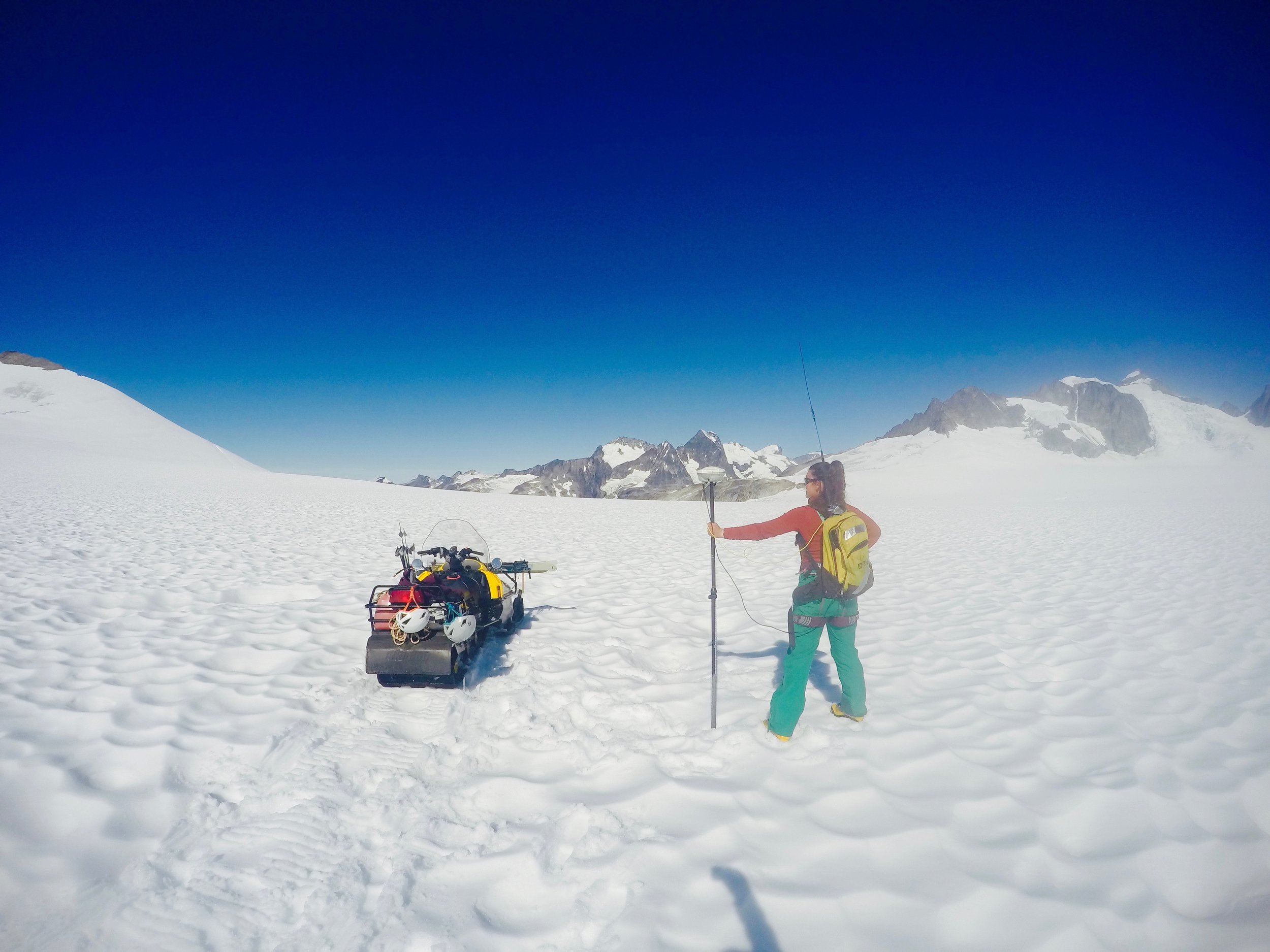
The author with her GPS jet pack! The GPS Rover (looks like a yellow backpack) and the antenna we use to find and re-survey the profile points. With the press of a few buttons it stores the latitude, longitude, and elevation of that particular point. Photo credit Brittany Ooman.
Using the rover we take measurements along both the longitudinal profiles, or center lines, of the glaciers, and the transverse profiles, the horizontal profiles across the glaciers. At each point we collect data about the latitude, longitude, and elevation. We primarily use the longitudinal profiles to monitor annual elevation changes along the glacier. To do this we snowmobile as close as possible to the point, then walk to within 0.5 m of the exact point, manually record the distance from the snow surface to the antenna using a measuring stick, and click measure on the rover. The rover, using GPS, measures the latitude, longitude, and elevation at that particular location. Then we pack up and head to the next profile point.
On the transverse profiles we primarily record data to determine the velocity of ice flow. To do this, we first use the GPS to measure the coordinates of points in a transect perpendicular to glacier flow, and mark the points with bamboo wands. Several days later, after the ice has had to time to flow a measurable distance, we record the new locations of the bamboo wands. Later, we will compile the data and use a simple equation to determine the ice flow rate based on the distance the wands moved during our sample time.

A map of the center of the Juneau Icefield with GPS survey profiles. The longitudinal profiles are represented with the dots running down the center lines of the glaciers. The transverse profiles are the block line sections running perpendicular to the longitudinal profiles. By collecting different data along both types of transects, we can paint a picture of elevation change over the entire area.
Using all these tools, benchmarks, base stations, and the GPS rover, we spend our days taking measurements in various areas of the icefield. Sometimes we spend most of our days measuring and sometimes we spend most of our days traveling to get to a small set of measurements. Surveying data is a critical field of study on the Juneau Icefield. The data we collect shows the surface elevation and ice flow velocity for this year. By monitoring the glacier annually, we can see changes in the characteristics and behavior of the glaciers of the icefield through time.
Links:
CrevasseZone.org: A site by long-time JIRPer Scott McGee dedicated to GPS Surveying of the Juneau Icefield.